Talaksan:Districts of the Bahamas (Labeled).png
Laki ng pasilip na ito: 578 x 600 na pixel. Ibang resolusyon: 231 x 240 na pixel | 463 x 480 na pixel | 825 x 856 na pixel.
Buong resolusyon ((825 × 856 pixel, laki ng talaksan: 21 KB, uri ng MIME: image/png))
|
|
Ito ay isang talaksan mula sa Wikimedia Commons. Makikita sa ibaba ang impormasyon mula sa pahina ng paglalarawan nito roon. |
.png?uselang=tl)

|
This locator map image could be re-created using vector graphics as an SVG file. This has several advantages; see Commons:Media for cleanup for more information. If an SVG form of this image is available, please upload it and afterwards replace this template with
{{vector version available|new image name}}.
It is recommended to name the SVG file “Districts of the Bahamas (Labeled).svg”—then the template Vector version available (or Vva) does not need the new image name parameter. |
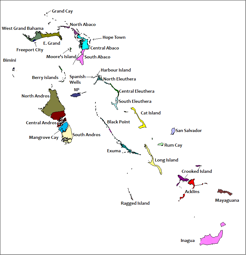
| Paglalarawan | == Summary == Created by Rarelibra for public domain use. Created using MapInfo Professional v7.5 and referencing various Bahamian map sources. en:Category:Maps of the Bahamas |
| Petsa | (UTC) |
| Pinanggalingan | |
| May-akda |
|
| This is a retouched picture, which means that it has been digitally altered from its original version. Modifications: Labells on the various Districts of The Bahamas have been placed.. The original can be viewed here: Districts of the Bahamas.png:
|
Ako, na may karapatang-ari ng akdang ito, ang naglalathala nito alinsunod sa ilalim ng sumusunod na mga lisensya:
| Ako, ang may tangan ng karapatang-ari ng akdang ito, ay pinakakawalan ang akdang ito sa nasasakupan ng madla. Magagamit ito sa buong mundo. Maaaring hindi ito posibleng legal sa ilang mga bansa; kung ganito: Ibinibigay ko sa sinuman ang karapatang gamitin ang akdang ito para sa anumang layunin, na walang mga kundisyon, maliban na lang kung ang ganyang mga kundisyon ay kailangan ng batas. |
Tala ng orihinal na pagkarga
This image is a derivative work of the following images:
- File:Districts_of_the_Bahamas.png licensed with PD-self
- 2006-11-05T20:18:13Z Stanmar 825x856 (23099 Bytes) {{Information| |Description= == Summary == Created by [[:en:User:Rarelibra|Rarelibra]] for public domain use. Created using MapInfo Professional v7.5 and referencing various Bahamian map sources. [[:en:Category:Maps of the B
Uploaded with derivativeFX
Nakaraan ng file
Pindutin ang araw/oras upang makita kung papaano ang itsura ng talaksan noong oras na iyon.
| Araw/Oras | Thumbnail | Mga dimensiyon | tagagamit | Kumento | |
|---|---|---|---|---|---|
| ngayon | 16:19, 16 Hunyo 2022 | | 825 × 856 (21 KB) | M.Bitton | Per request on en:Wikipedia:Graphics_Lab/Map_workshop#Request_spelling_fix_for_File:Districts_of_the_Bahamas_(Labeled).png |
| 19:54, 27 Hunyo 2010 |  | 825 × 856 (36 KB) | Uniongreen113 | {{Information |Description=== Summary == Created by Rarelibra for public domain use. Created using MapInfo Professional v7.5 and referencing various Bahamian map sources. en:Category:Maps of the Bahamas |Source=*[[:File:Distri |
.png)
Mga ugnay
Nakaturo sa talaksan na ito ang mga sumusunod na mga pahina:
Pandaigdigang paggamit sa file
Ginagamit ng mga sumusunod na wiki ang file na ito:
- Paggamit sa az.wiktionary.org
- Paggamit sa en.wikipedia.org
- Paggamit sa eo.wikipedia.org
- Paggamit sa fo.wikipedia.org
- Paggamit sa hu.wikipedia.org
- Paggamit sa id.wikipedia.org
- Paggamit sa is.wikipedia.org
- Paggamit sa it.wikipedia.org
- Paggamit sa la.wikipedia.org
- Paggamit sa lfn.wikipedia.org
- Paggamit sa ms.wikipedia.org
- Paggamit sa pt.wikipedia.org
- Paggamit sa sd.wikipedia.org
- Paggamit sa sv.wikipedia.org
- Paggamit sa vi.wikipedia.org
.png)