Talaksan:2010 Maule earthquake intensity USGS.jpg

Laki ng pasilip na ito: 510 x 599 na pixel. Ibang resolusyon: 204 x 240 na pixel | 612 x 719 na pixel.
Buong resolusyon ((612 × 719 pixel, laki ng talaksan: 110 KB, uri ng MIME: image/jpeg))
|
|
Ito ay isang talaksan mula sa Wikimedia Commons. Makikita sa ibaba ang impormasyon mula sa pahina ng paglalarawan nito roon. |
Buod
| Paglalarawan |
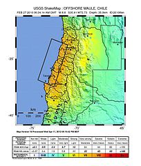
English: Shake map of the magnitude 8.8 earthquake offshore Chile on February 27, 2010. Epicenter marked at star. Seventh version of the map, realized by USGS on 5 March 2010 at 03:00:13 AM MST. |
| Petsa | |
| Pinanggalingan | USGS |
| May-akda | USGS |
| Camera location | | View this and other nearby images on: OpenStreetMap |
|---|
Paglilisensiya
This image is in the public domain in the United States because it only contains materials that originally came from the United States Geological Survey, an agency of the United States Department of the Interior. For more information, see the official USGS copyright policy.
|
Nakaraan ng file
Pindutin ang araw/oras upang makita kung papaano ang itsura ng talaksan noong oras na iyon.
| Araw/Oras | Thumbnail | Mga dimensiyon | tagagamit | Kumento | |
|---|---|---|---|---|---|
| ngayon | 02:30, 15 Agosto 2013 | | 612 × 719 (110 KB) | Adelpine | Update to 10th version |
| 21:20, 21 Marso 2010 |  | 612 × 720 (99 KB) | Adelpine | ||
| 17:31, 2 Marso 2010 |  | 612 × 720 (100 KB) | RapidR~commonswiki | update to latest map (v6) | |
| 08:32, 27 Pebrero 2010 |  | 612 × 713 (107 KB) | Andreas Willow | {{Information |Description={{en|1=Shake map of the magnitude 8.3 earthquake offshore Chile on February 27, 2010. Epicenter marked at star. Second version of the map, realized by USGS on 27 February |
Mga ugnay
Nakaturo sa talaksan na ito ang mga sumusunod na mga pahina:
Pandaigdigang paggamit sa file
Ginagamit ng mga sumusunod na wiki ang file na ito:
- Paggamit sa ar.wikipedia.org
- Paggamit sa ca.wikipedia.org
- Paggamit sa de.wikipedia.org
- Paggamit sa en.wikipedia.org
- Paggamit sa en.wikinews.org
- Paggamit sa eo.wikinews.org
- Paggamit sa es.wikipedia.org
- Paggamit sa fi.wikinews.org
- Paggamit sa fr.wikipedia.org
- Paggamit sa fr.wikinews.org
- Paggamit sa gl.wikipedia.org
- Paggamit sa hu.wikipedia.org
- Paggamit sa incubator.wikimedia.org
- Paggamit sa it.wikipedia.org
- Paggamit sa it.wikinews.org
- Paggamit sa ja.wikipedia.org
- Paggamit sa ja.wikinews.org
- Paggamit sa ms.wikipedia.org
- Paggamit sa nl.wikipedia.org
- Paggamit sa pl.wikipedia.org
- Paggamit sa simple.wikipedia.org
- Paggamit sa sk.wikipedia.org
- Paggamit sa tr.wikipedia.org
- Paggamit sa tr.wikinews.org
- Paggamit sa zh-min-nan.wikipedia.org
- Paggamit sa zh.wikipedia.org