Talaksan:Batman districts.png

Laki ng pasilip na ito: 601 x 599 na pixel. Ibang resolusyon: 241 x 240 na pixel | 481 x 480 na pixel | 780 x 778 na pixel.
Buong resolusyon ((780 × 778 pixel, laki ng talaksan: 18 KB, uri ng MIME: image/png))
|
|
Ito ay isang talaksan mula sa Wikimedia Commons. Makikita sa ibaba ang impormasyon mula sa pahina ng paglalarawan nito roon. |

|
This locator map image could be re-created using vector graphics as an SVG file. This has several advantages; see Commons:Media for cleanup for more information. If an SVG form of this image is available, please upload it and afterwards replace this template with
{{vector version available|new image name}}.
It is recommended to name the SVG file “Batman districts.svg”—then the template Vector version available (or Vva) does not need the new image name parameter. |
Buod
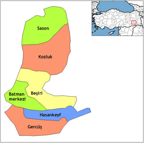
| Paglalarawan | Map of the districts of Batman province in Turkey. Created by Rarelibra 18:55, 1 December 2006 (UTC) for public domain use, using MapInfo Professional v8.5 and various mapping resources. Edited by One Homo Sapiens Corrected text where İ,Ş,ı,ğ,or ş occurs in name. Source: [statoids-com]. Increased font size and enhanced color differences among adjacent districts. |
| Petsa | 1 Disyembre 2006 (original upload date) |
| Pinanggalingan | No machine-readable source provided. Own work assumed (based on copyright claims). |
| May-akda | No machine-readable author provided. Rarelibra assumed (based on copyright claims). |
Paglilisensiya
| Ako, ang may tangan ng karapatang-ari ng akdang ito, ay pinakakawalan ang akdang ito sa nasasakupan ng madla. Magagamit ito sa buong mundo. Maaaring hindi ito posibleng legal sa ilang mga bansa; kung ganito: Ibinibigay ko sa sinuman ang karapatang gamitin ang akdang ito para sa anumang layunin, na walang mga kundisyon, maliban na lang kung ang ganyang mga kundisyon ay kailangan ng batas. |
Nakaraan ng file
Pindutin ang araw/oras upang makita kung papaano ang itsura ng talaksan noong oras na iyon.
| Araw/Oras | Thumbnail | Mga dimensiyon | tagagamit | Kumento | |
|---|---|---|---|---|---|
| ngayon | 05:42, 10 Pebrero 2011 | | 780 × 778 (18 KB) | Materialscientist | crop whitespace |
| 21:00, 28 Disyembre 2008 |  | 1,056 × 816 (19 KB) | One Homo Sapiens | Corrected text where İ,Ş,ı,ğ,or ş occurs in name. Source: [statoids-com]. Increased font size and enhanced color differences among adjacent districts. | |
| 18:55, 1 Disyembre 2006 |  | 1,056 × 816 (23 KB) | Rarelibra | Map of the districts of Batman province in Turkey. Created by ~~~~ for public domain use, using MapInfo Professional v8.5 and various mapping resources. |
Mga ugnay
Nakaturo sa talaksan na ito ang mga sumusunod na mga pahina:
Pandaigdigang paggamit sa file
Ginagamit ng mga sumusunod na wiki ang file na ito:
- Paggamit sa ar.wikipedia.org
- Paggamit sa arz.wikipedia.org
- Paggamit sa ast.wikipedia.org
- Paggamit sa az.wikipedia.org
- Paggamit sa bs.wikipedia.org
- Paggamit sa ca.wikipedia.org
- Paggamit sa ceb.wikipedia.org
- Paggamit sa cs.wikipedia.org
- Paggamit sa de.wikipedia.org
- Paggamit sa diq.wikipedia.org
- Paggamit sa en.wikipedia.org
- Paggamit sa en.wiktionary.org
- Paggamit sa eo.wikipedia.org
- Paggamit sa es.wikipedia.org
- Paggamit sa eu.wikipedia.org
- Paggamit sa fa.wikipedia.org
- Paggamit sa fi.wikipedia.org
- Paggamit sa fr.wikipedia.org
- Paggamit sa hr.wikipedia.org
Tingnan ang karagdagang pandaigdigang paggamit sa file na ito.