Talaksan:Battle of whitemarsh view.jpg

Buong resolusyon ((851 × 576 pixel, laki ng talaksan: 130 KB, uri ng MIME: image/jpeg))
|
|
Ito ay isang talaksan mula sa Wikimedia Commons. Makikita sa ibaba ang impormasyon mula sa pahina ng paglalarawan nito roon. |
Buod
| Paglalarawan |
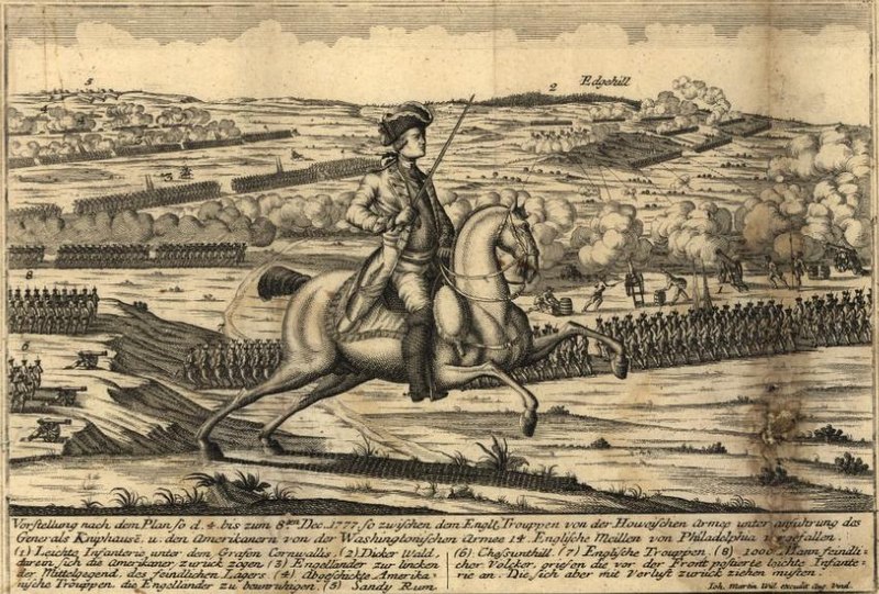
View from the British positions at the en:Battle of White Marsh. Chestnut Hill is in the lower left of the image, Sandy Run in the upper left, and Edge Hill in the upper right. Vorstellung nach dem Plan so d. 4. bis zum 8ten Dec. 1777 so zwischen dem Engl. Trouppen von der Howeischen Armee unter Anführung des Generals Kniphausē u. den Amerikanern von der Washingtonischen Armee 14 englische Meilen von Philadelphia vergefallen... |
| Petsa | 22 Setyembre 2006 (original upload date) |
| Pinanggalingan | Library of Congress, Geography and Map Division. <http://hdl.loc.gov/loc.gmd/g3821sm.gas00001> (via en.wikipedia; description page is/was here). |
| May-akda | By Johann Martin Will. Map. Augsburg, Germany: ?, 1777 |
Paglilisensiya
|
This work is in the public domain in its country of origin and other countries and areas where the copyright term is the author's life plus 70 years or fewer.
| |
| Nakilala ang talaksan bilang malaya mula sa nalalamang mga paghahangga sa ilalim ng batas sa karapatang-ari, kasama ang lahat ng mga kaugnay at karatig na mga karapatan. | |
Tala ng orihinal na pagkarga
(All user names refer to en.wikipedia)
- 2006-09-22 22:53 Alphageekpa 851×576×8 (133411 bytes) == Summary == View from the British positions at the [[Battle of White Marsh]]. Chestnut Hill is in the lower left of the image, Sandy Run in the upper left, and Edge Hill in the upper right. ''Vorstellung nach dem Plan so d. 4. bis zum 8ten Dec. 1777 s
Nakaraan ng file
Pindutin ang araw/oras upang makita kung papaano ang itsura ng talaksan noong oras na iyon.
| Araw/Oras | Thumbnail | Mga dimensiyon | tagagamit | Kumento | |
|---|---|---|---|---|---|
| ngayon | 16:18, 20 Oktubre 2007 | | 851 × 576 (130 KB) | Fryed-peach | {{Information |Description=View from the British positions at the en:Battle of White Marsh. Chestnut Hill is in the lower left of the image, Sandy Run in the upper left, and Edge Hill in the upper right. ''Vorstellung nach dem Plan so d. 4. bis zum |
Mga ugnay
Nakaturo sa talaksan na ito ang mga sumusunod na mga pahina:
Pandaigdigang paggamit sa file
Ginagamit ng mga sumusunod na wiki ang file na ito:
- Paggamit sa en.wikipedia.org
- Paggamit sa fr.wikipedia.org
- Paggamit sa ja.wikipedia.org
- Paggamit sa ko.wikipedia.org
- Paggamit sa ru.wikipedia.org
- Paggamit sa www.wikidata.org
- Paggamit sa zh.wikipedia.org