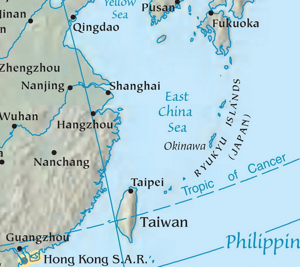
Talaksan:East China Sea Map.jpg
East_China_Sea_Map.jpg ((600 × 533 pixel, laki ng talaksan: 88 KB, uri ng MIME: image/jpeg))
Nakaraan ng file
Pindutin ang araw/oras upang makita kung papaano ang itsura ng talaksan noong oras na iyon.
| Araw/Oras | Thumbnail | Mga dimensiyon | tagagamit | Kumento | |
|---|---|---|---|---|---|
| ngayon | 13:26, 13 Hunyo 2007 |  | 600 × 533 (88 KB) | Zeman | Map of the East China Sea. Mapa Východočínského moře (popisky v angličtině). Source: tr:Resim:DoğuÇinDenizi.jpg Licence: public domain, because it originally comes from the CIA World Factbook, i.e. from a United States federal governemental |
Mga ugnay
Nakaturo sa talaksan na ito ang mga sumusunod na mga pahina:
Pandaigdigang paggamit sa file
Ginagamit ng mga sumusunod na wiki ang file na ito:
- Paggamit sa ar.wikipedia.org
- Paggamit sa arz.wikipedia.org
- Paggamit sa bcl.wikipedia.org
- Paggamit sa be.wikipedia.org
- Paggamit sa bn.wikipedia.org
- Paggamit sa cdo.wikipedia.org
- Paggamit sa cs.wikipedia.org
- Paggamit sa en.wikipedia.org
- Paggamit sa eo.wikipedia.org
- Paggamit sa es.wikipedia.org
- Paggamit sa eu.wikipedia.org
- Paggamit sa fa.wikipedia.org
- Paggamit sa gl.wikipedia.org
- Paggamit sa he.wikipedia.org
- Paggamit sa hr.wikipedia.org
- Paggamit sa hy.wikipedia.org
- Paggamit sa id.wikipedia.org
- Paggamit sa ilo.wikipedia.org
- Paggamit sa incubator.wikimedia.org
- Paggamit sa is.wikipedia.org
- Paggamit sa it.wikipedia.org
- Paggamit sa ja.wikipedia.org
- Paggamit sa jv.wikipedia.org
- Paggamit sa kk.wikipedia.org
- Paggamit sa ko.wikipedia.org
- Paggamit sa lt.wikipedia.org
- Paggamit sa mk.wikipedia.org
- Paggamit sa ml.wikipedia.org
- Paggamit sa ms.wikipedia.org
- Paggamit sa no.wikipedia.org
- Paggamit sa pa.wikipedia.org
- Paggamit sa pl.wiktionary.org
- Paggamit sa pt.wikipedia.org
- Paggamit sa ro.wikipedia.org
- Paggamit sa ru.wikipedia.org
- Paggamit sa ru.wikinews.org
Tingnan ang karagdagang pandaigdigang paggamit sa file na ito.


