Talaksan:Fergana valley topo political.png
Walang resolusyong mataas.
Fergana_valley_topo_political.png ((375 × 178 pixel, laki ng talaksan: 136 KB, uri ng MIME: image/png))
|
|
Ito ay isang talaksan mula sa Wikimedia Commons. Makikita sa ibaba ang impormasyon mula sa pahina ng paglalarawan nito roon. |
| Paglalarawan |
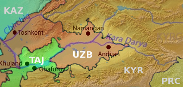
English: Map of the Fergana valley (highlighted) in Central Asia, national territories color coded, with shortened names, using boundaries from CIA 2001 Map File:Tajikistan_2001_CIA_map.jpg |
| Petsa | (UTC) |
| Pinanggalingan | |
| May-akda |
|
| This is a retouched picture, which means that it has been digitally altered from its original version. Modifications: Overlay national territories, highlight Fergana Valley. The original can be viewed here: Syrdaryamap.png:
|
Ako, na may karapatang-ari ng akdang ito, ang naglalathala nito alinsunod sa ilalim ng sumusunod na mga lisensya:
Ang talaksang ito ay nakalisensiya sa ilalim ng lisensiyang Creative Commons Atribusyon-Pagpapamahaging Magkatulad 3.0 Walang Daungan, 2.5 Heneriko, 2.0 Heneriko at 1.0 Heneriko.
- Malaya kang:
- para ibahagi – para kopyahin, ipamahagi, at i-transmit ang akda
- para i-remix – para i-adapt ang akda
- Sa ilalim ng mga kondisyong ito:
- atribusyon – Dapat magbigay ka ng isang maayos na pag-credit, ibigay ang link sa lisensiya, at tukuyin kung may mga pagbabagong ginawa. Magagawa mo ito sa isang risonableng paraan, pero hindi sa paraan na para bang ineendorso ka o ng paggamit mo ng naglisensiya sa'yo.
- share alike – Kung ire-remix mo, babaguhin, o magdadagdag ka sa materyal, dapat mong ipamahagi ang mga ambag mo sa ilalim ng pareho o katulad na lisensiya.

|
Pinapayagan ang pagkopya, pamamahagi, at/o pagbabago sa dokumentong ito sa ilalim ng mga nakasaad sa GNU Free Documentation License, Bersyon 1.2 o kahit anong mas bagong bersyong nilathala ng Free Software Foundation; nang walang pabago-bagong bahagi, walang teksto sa front-cover, at walang teksto sa back-cover. May nakalagay na kopya ng lisensiya sa bahaging pinamagatang GNU Free Documentation License. |
Makakapili ka ng lisensiyang gusto mo.
Tala ng orihinal na pagkarga
This image is a derivative work of the following images:
- File:Syrdaryamap.png licensed with Cc-by-sa-3.0,2.5,2.0,1.0, GFDL
- 2010-02-07T03:04:09Z Shannon1 1101x866 (1580396 Bytes) {{Information |Description={{en|1=Map of the watershed of the Syr Darya in Central Asia, that drains to the Aral Sea.}} |Source=Background and river course data from http://www2.demis.nl/mapserver/mapper.asp |Author=Backgrou
Uploaded with derivativeFX
Nakaraan ng file
Pindutin ang araw/oras upang makita kung papaano ang itsura ng talaksan noong oras na iyon.
| Araw/Oras | Thumbnail | Mga dimensiyon | tagagamit | Kumento | |
|---|---|---|---|---|---|
| ngayon | 19:39, 14 Hunyo 2010 | | 375 × 178 (136 KB) | T L Miles | {{Information |Description={{en|1=Map of the watershed of the Syr Darya in Central Asia, that drains to the Aral Sea.}} |Source=*File:Syrdaryamap.png |Date=2010-06-14 19:38 (UTC) |Author=*File:Syrdaryamap.png: Background layer attributed to DE |
Mga ugnay
Nakaturo sa talaksan na ito ang mga sumusunod na mga pahina:
Pandaigdigang paggamit sa file
Ginagamit ng mga sumusunod na wiki ang file na ito:
- Paggamit sa da.wikipedia.org
- Paggamit sa de.wikipedia.org
- Paggamit sa de.wikivoyage.org
- Paggamit sa en.wikipedia.org
- Paggamit sa en.wikivoyage.org
- Paggamit sa fa.wikipedia.org
- Paggamit sa fi.wikipedia.org
- Paggamit sa hi.wikipedia.org
- Paggamit sa it.wikipedia.org
- Paggamit sa ml.wikipedia.org
- Paggamit sa mn.wikipedia.org
- Paggamit sa ms.wikipedia.org
- Paggamit sa pl.wikipedia.org
- Paggamit sa ro.wikipedia.org
- Paggamit sa sv.wikipedia.org
- Paggamit sa ta.wikipedia.org
- Paggamit sa te.wikipedia.org
- Paggamit sa th.wikipedia.org
- Paggamit sa uk.wikipedia.org
- Paggamit sa zh.wikivoyage.org