Talaksan:Gray Wolf Distribution.gif
Laki ng pasilip na ito: 800 x 238 na pixel. Ibang resolusyon: 320 x 95 na pixel | 1,168 x 347 na pixel.
Buong resolusyon ((1,168 × 347 pixel, laki ng talaksan: 17 KB, uri ng MIME: image/gif))
|
|
Ito ay isang talaksan mula sa Wikimedia Commons. Makikita sa ibaba ang impormasyon mula sa pahina ng paglalarawan nito roon. |
Buod
| Paglalarawan |
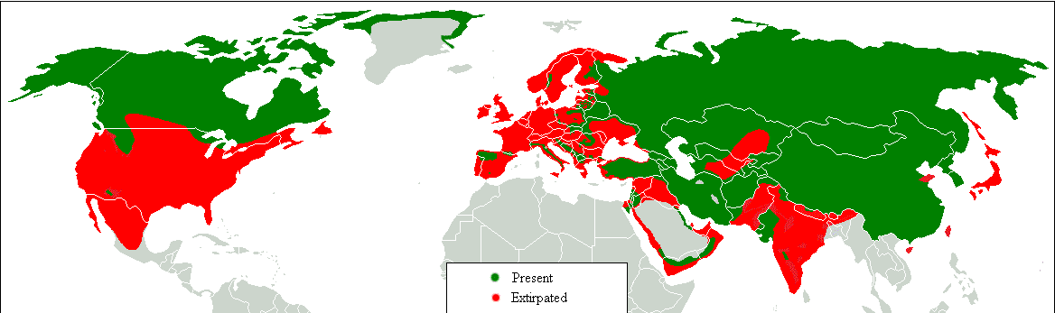
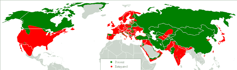
Dansk: Udbredelseskort. Grøn: idag, rød: historisk. English: Range map. Green, present; red, former. Հայերեն: Գայլերի բնակեցման քարտեզ, կանաչ գույնով պատկերված է ներկա արեալը, իսկ կարմիր գույնով՝ պատմական: |
| Petsa | |
| Pinanggalingan | Transferred from en.wikipedia to Commons.;. |
| May-akda | Tommyknocker at English Wikipedia |

|
This biogeographical map image could be re-created using vector graphics as an SVG file. This has several advantages; see Commons:Media for cleanup for more information. If an SVG form of this image is available, please upload it and afterwards replace this template with
{{vector version available|new image name}}.
It is recommended to name the SVG file “Gray Wolf Distribution.svg”—then the template Vector version available (or Vva) does not need the new image name parameter. |
Paglilisensiya
| Ang akdang ito ay pinakawalan sa sakop ng madla ng may-akda nito, si Tommyknocker at English Wikipedia. Magagamit ito sa buong daigdig. Maaaring hindi ito posibleng legal sa ilang mga bansa; kung ganito: Ibinibigay ni Tommyknocker kaninuman ang karapatang gamitin ang akdang ito para sa anumang layunin, na walang anumang kundisyon, maliban na lamang kung ang ganyang mga kundisyon ay kinakailangan sa batas. |
Tala ng orihinal na pagkarga
Original description page is/was here(All user names refer to en.wikipedia)
- 2007-03-03 12:04 Tommyknocker 1168×347×8 (16467 bytes)
| Annotations | This image is annotated: View the annotations at Commons |
Nakaraan ng file
Pindutin ang araw/oras upang makita kung papaano ang itsura ng talaksan noong oras na iyon.
| Araw/Oras | Thumbnail | Mga dimensiyon | tagagamit | Kumento | |
|---|---|---|---|---|---|
| ngayon | 09:18, 17 Pebrero 2018 | 1,168 × 347 (17 KB) | William Harris | Refer discussion page - North America | |
| 09:08, 16 Pebrero 2018 | 1,168 × 347 (17 KB) | William Harris | Refer Discussion page - Caucasus, Turkey and Kyrgyzstan | ||
| 06:29, 15 Pebrero 2018 | 1,168 × 347 (17 KB) | William Harris | Refer Discussion page - Iran, Pakistan and India | ||
| 05:58, 14 Pebrero 2018 | 1,168 × 347 (16 KB) | William Harris | Refer Discussion page - India, Nepal, Bhutan, China | ||
| 11:41, 13 Pebrero 2018 | 1,168 × 347 (16 KB) | William Harris | Amended for both Koreas and all but southern China based on IUNC Red List: http://www.iucnredlist.org/details/3746/0 | ||
| 11:36, 12 Pebrero 2018 | 1,168 × 347 (16 KB) | William Harris | British Columbia distribution included based on: * https://www.researchgate.net/figure/Map-of-British-Columbia-showing-the-elevation-and-distribution-of-wolf-sampling_fig5_260037025 * http://www.env.gov.bc.ca/fw/wildlife/management-issues/docs/grey_wol... | ||
| 23:55, 9 Pebrero 2018 | 1,168 × 347 (16 KB) | Maphobbyist | Complete | ||
| 22:54, 9 Pebrero 2018 | 1,168 × 347 (16 KB) | Maphobbyist | Final chck | ||
| 22:38, 9 Pebrero 2018 | 1,168 × 347 (16 KB) | Maphobbyist | Again check | ||
| 20:55, 9 Pebrero 2018 | 1,168 × 347 (16 KB) | Maphobbyist | Check |
Mga ugnay
Nakaturo sa talaksan na ito ang mga sumusunod na mga pahina:
Pandaigdigang paggamit sa file
Ginagamit ng mga sumusunod na wiki ang file na ito:
- Paggamit sa af.wikipedia.org
- Paggamit sa am.wikipedia.org
- Paggamit sa azb.wikipedia.org
- Paggamit sa bn.wikipedia.org
- Paggamit sa bs.wikipedia.org
- Paggamit sa cy.wikipedia.org
- Paggamit sa de.wikipedia.org
- Paggamit sa diq.wikipedia.org
- Paggamit sa en.wikipedia.org
- Paggamit sa fa.wikipedia.org
- Paggamit sa ga.wikipedia.org
- Paggamit sa gl.wikipedia.org
- Paggamit sa gu.wikipedia.org
- Paggamit sa he.wikipedia.org
- Paggamit sa hy.wikipedia.org
- Paggamit sa hy.wikiquote.org
- Paggamit sa ia.wikipedia.org
- Paggamit sa ja.wikipedia.org
- Paggamit sa kbd.wikipedia.org
- Paggamit sa ko.wikipedia.org
- Paggamit sa ku.wikipedia.org
- Paggamit sa lb.wikipedia.org
- Paggamit sa mk.wikipedia.org
- Paggamit sa mn.wikipedia.org
- Paggamit sa ms.wikipedia.org
- Paggamit sa myv.wikipedia.org
- Paggamit sa ne.wikipedia.org
- Paggamit sa oc.wikipedia.org
- Paggamit sa pa.wikipedia.org
- Paggamit sa ro.wikipedia.org
- Paggamit sa ru.wikipedia.org
- Paggamit sa so.wikipedia.org
- Paggamit sa stq.wikipedia.org
- Paggamit sa sv.wikipedia.org
- Paggamit sa ta.wikipedia.org
- Paggamit sa zh-min-nan.wikipedia.org
- Paggamit sa zh-yue.wikipedia.org