Talaksan:Kise Bridge YorkCo PA 2.JPG

Buong resolusyon((3,083 × 3,083 pixel, laki ng talaksan: 4.12 MB, uri ng MIME: image/jpeg))

Buod

Paglalarawan
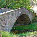
English: Kise Mill Bridge listed on the NRHP on June 22, 1988. At Legislative Route 66003 over Bennett Run, east of Lewisberry, in Newberry Township, York County, Pennsylvania. It is a very impressive camelback bridge built 1915, one lane. It is also part of the Kise Mill Bridge Historic District, listed in 1980.

This is an image of a place or building that is listed on the National Register of Historic Places in the United States of America. Its reference number is 88000799.

Petsa Kinuha noong 23 Setyembre 2013, 18:53:24
Pinanggalingan Sariling gawa
May-akda Smallbones
Camera location40° 06′ 56″ N, 76° 48′ 38″ W Kartographer map based on OpenStreetMap.View this and other nearby images on: OpenStreetMapinfo

This is an image of a place or building that is listed on the National Register of Historic Places in the United States of America. Its reference number is 80003650.


Paglilisensiya

Ako, na may karapatang-ari ng akdang ito, ang naglalathala nito alinsunod sa ilalim ng sumusunod na mga lisensya:
w:tl:Creative Commons
atribusyon share alike
Lisensyado ang file na ito sa ilalim ng lisensiyang Creative Commons Attribution-Share Alike 3.0 Unported.
Malaya kang:
  • para ibahagi – para kopyahin, ipamahagi, at i-transmit ang akda
  • para i-remix – para i-adapt ang akda
Sa ilalim ng mga kondisyong ito:
  • atribusyon – Dapat magbigay ka ng isang maayos na pag-credit, ibigay ang link sa lisensiya, at tukuyin kung may mga pagbabagong ginawa. Magagawa mo ito sa isang risonableng paraan, pero hindi sa paraan na para bang ineendorso ka o ng paggamit mo ng naglisensiya sa'yo.
  • share alike – Kung ire-remix mo, babaguhin, o magdadagdag ka sa materyal, dapat mong ipamahagi ang mga ambag mo sa ilalim ng pareho o katulad na lisensiya.


Captions

Add a one-line explanation of what this file represents

Items portrayed in this file

depicts English

copyrighted English

23 Setyembre 2013

40°6'56.002"N, 76°48'38.002"W

Nakaraan ng file

Pindutin ang araw/oras upang makita kung papaano ang itsura ng talaksan noong oras na iyon.

Araw/OrasThumbnailMga dimensiyontagagamitKumento
ngayon18:23, 24 Setyembre 2013Thumbnail para sa bersyon noong 18:23, 24 Setyembre 20133,083 × 3,083 (4.12 MB)SmallbonesUser created page with UploadWizard

Nakaturo sa talaksan na ito ang mga sumusunod na mga pahina:

Pandaigdigang paggamit sa file

Metadata