Talaksan:Location-of-Liancourt-rocks-en.png
Laki ng pasilip na ito: 800 x 400 na pixel. Ibang resolusyon: 320 x 160 na pixel | 938 x 469 na pixel.
Buong resolusyon ((938 × 469 pixel, laki ng talaksan: 286 KB, uri ng MIME: image/png))
|
|
Ito ay isang talaksan mula sa Wikimedia Commons. Makikita sa ibaba ang impormasyon mula sa pahina ng paglalarawan nito roon. |

|
This locator map image could be re-created using vector graphics as an SVG file. This has several advantages; see Commons:Media for cleanup for more information. If an SVG form of this image is available, please upload it and afterwards replace this template with
{{vector version available|new image name}}.
It is recommended to name the SVG file “Location-of-Liancourt-rocks-en.svg”—then the template Vector version available (or Vva) does not need the new image name parameter. |
Buod
| Paglalarawan |
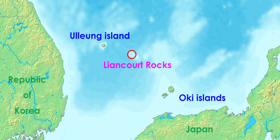
English: Liancourt rocks, in Japan called Takeshima and in North and South Korea called Dokdo (Tokto).
Ido: Liancourt roki, en Japonia nomata Takeshima ed en Nord e Sud-Korea nomata Dokto (Tokto). |
||||
| Petsa | 12 Mayo 2006 (original upload date) | ||||
| Pinanggalingan | http://www.demis.nl/wms/mapclip.htm | ||||
| May-akda | demis.nl | ||||
| Permiso (Muling paggamit sa file) |
|
Nakaraan ng file
Pindutin ang araw/oras upang makita kung papaano ang itsura ng talaksan noong oras na iyon.
| Araw/Oras | Thumbnail | Mga dimensiyon | tagagamit | Kumento | |
|---|---|---|---|---|---|
| ngayon | 05:36, 17 Hulyo 2008 | | 938 × 469 (286 KB) | Ponta2 | Reverted to version as of 19:08, 6 April 2008 |
| 12:03, 16 Hulyo 2008 |  | 800 × 400 (332 KB) | 쿠도군 | ||
| 19:08, 6 Abril 2008 |  | 938 × 469 (286 KB) | Eurodollers | == Summary == {{Information |Description={{en|Location of Liancourt Rocks, where Korea and Japan claim that Liancourt rocks is their own territory.}} |Source= http://www.demis.nl/wms/mapclip.htm |Date= 12 May 2006 (original upload date) |Author= demis.nl | |
| 01:41, 5 Hunyo 2007 |  | 640 × 320 (57 KB) | Tene~commonswiki | Optimised (0;r) | |
| 09:43, 18 Oktubre 2006 |  | 640 × 320 (60 KB) | Conscious | Reverted to earlier revision | |
| 14:00, 12 Mayo 2006 |  | 640 × 320 (60 KB) | LERK | Location of Liancourt Rocks, where Korea and Japan claim that Liancourt rocks is their own territoriy. {{demis-pd}} Category:Maps of disputed territories Category:Maps of Korea Category:Islands of Korea Category:Maps of Japan [[Category:Is |
Mga ugnay
Nakaturo sa talaksan na ito ang mga sumusunod na mga pahina:
Pandaigdigang paggamit sa file
Ginagamit ng mga sumusunod na wiki ang file na ito:
- Paggamit sa af.wikipedia.org
- Paggamit sa ar.wikipedia.org
- Paggamit sa bat-smg.wikipedia.org
- Paggamit sa bh.wikipedia.org
- Paggamit sa ca.wikipedia.org
- Paggamit sa de.wikipedia.org
- Paggamit sa en.wikipedia.org
- Paggamit sa eo.wikipedia.org
- Paggamit sa es.wikipedia.org
- Paggamit sa fa.wikipedia.org
- Paggamit sa fi.wikipedia.org
- Paggamit sa fr.wikipedia.org
- Paggamit sa he.wikipedia.org
- Paggamit sa hi.wikipedia.org
- Paggamit sa id.wikipedia.org
- Paggamit sa it.wikipedia.org
- Paggamit sa ja.wikibooks.org
- Paggamit sa lt.wikipedia.org
- Paggamit sa ms.wikipedia.org
- Paggamit sa nl.wikipedia.org
- Paggamit sa no.wikipedia.org
- Paggamit sa pa.wikipedia.org
- Paggamit sa pl.wikipedia.org
- Paggamit sa pt.wikipedia.org
- Paggamit sa ro.wikipedia.org
- Paggamit sa simple.wikipedia.org
Tingnan ang karagdagang pandaigdigang paggamit sa file na ito.