Talaksan:Map of Lebanon.png
Walang resolusyong mataas.
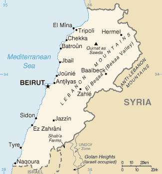
Map_of_Lebanon.png ((325 × 349 pixel, laki ng talaksan: 10 KB, uri ng MIME: image/png))
|
|
Ito ay isang talaksan mula sa Wikimedia Commons. Makikita sa ibaba ang impormasyon mula sa pahina ng paglalarawan nito roon. |
Map of Lebanon from de wiki/CIA World Factbook. Attribution note: this image's update on 2010-09-23 was originally done by Shimgray at English Wikipedia.
This image is in the public domain because it contains materials that originally came from the United States Central Intelligence Agency's World Factbook.
|
 |
Nakaraan ng file
Pindutin ang araw/oras upang makita kung papaano ang itsura ng talaksan noong oras na iyon.
| Araw/Oras | Thumbnail | Mga dimensiyon | tagagamit | Kumento | |
|---|---|---|---|---|---|
| ngayon | 01:24, 2 Hulyo 2012 | | 325 × 349 (10 KB) | Ras67 | cropped |
| 09:31, 23 Setyembre 2010 |  | 330 × 354 (10 KB) | Rehman | updated file from English Wikipedia | |
| 13:25, 6 Marso 2005 |  | 330 × 354 (10 KB) | Carlosar~commonswiki | Map of Lebanon from de wiki (http://de.wikipedia.org/upload/8/85/Libanon.png)/CIA World Factbook. |
Mga ugnay
Nakaturo sa talaksan na ito ang mga sumusunod na mga pahina:
Pandaigdigang paggamit sa file
Ginagamit ng mga sumusunod na wiki ang file na ito:
- Paggamit sa af.wikipedia.org
- Paggamit sa arz.wikipedia.org
- Paggamit sa ast.wikipedia.org
- Paggamit sa as.wikipedia.org
- Paggamit sa azb.wikipedia.org
- Paggamit sa ban.wikipedia.org
- Paggamit sa bcl.wikipedia.org
- Paggamit sa be-tarask.wikipedia.org
- Paggamit sa bg.wikipedia.org
- Paggamit sa ca.wikipedia.org
- Paggamit sa ceb.wikipedia.org
- Paggamit sa ckb.wikipedia.org
- Paggamit sa cs.wikipedia.org
- Paggamit sa da.wikipedia.org
- Paggamit sa de.wikinews.org
- Paggamit sa diq.wikipedia.org
- Paggamit sa dsb.wikipedia.org
- Paggamit sa el.wikipedia.org
- Paggamit sa en.wikipedia.org
- Geography of Lebanon
- Wikipedia talk:In the news/Archive 8
- 2008 Tripoli, Lebanon bombings
- United Nations Security Council Resolution 436
- United Nations Security Council Resolution 509
- United Nations Security Council Resolution 564
- United Nations Security Council Resolution 1095
- Category:Populated places in Lebanon
- Energy in Lebanon
- Geothermal energy in Lebanon
- Paggamit sa en.wikinews.org
- Paggamit sa eo.wikipedia.org
- Paggamit sa es.wikipedia.org
- Paggamit sa eu.wikipedia.org
- Paggamit sa fa.wikipedia.org
Tingnan ang karagdagang pandaigdigang paggamit sa file na ito.