Talaksan:New 2000 hispanic percent.gif
Laki ng pasilip na ito: 776 x 600 na pixel. Ibang resolusyon: 311 x 240 na pixel | 621 x 480 na pixel | 994 x 768 na pixel | 1,280 x 989 na pixel | 2,604 x 2,012 na pixel.
Buong resolusyon ((2,604 × 2,012 pixel, laki ng talaksan: 685 KB, uri ng MIME: image/gif))
|
|
Ito ay isang talaksan mula sa Wikimedia Commons. Makikita sa ibaba ang impormasyon mula sa pahina ng paglalarawan nito roon. |

|
This ethnographic map image could be re-created using vector graphics as an SVG file. This has several advantages; see Commons:Media for cleanup for more information. If an SVG form of this image is available, please upload it and afterwards replace this template with
{{vector version available|new image name}}.
It is recommended to name the SVG file “New 2000 hispanic percent.svg”—then the template Vector version available (or Vva) does not need the new image name parameter. |
Buod
| Paglalarawan |
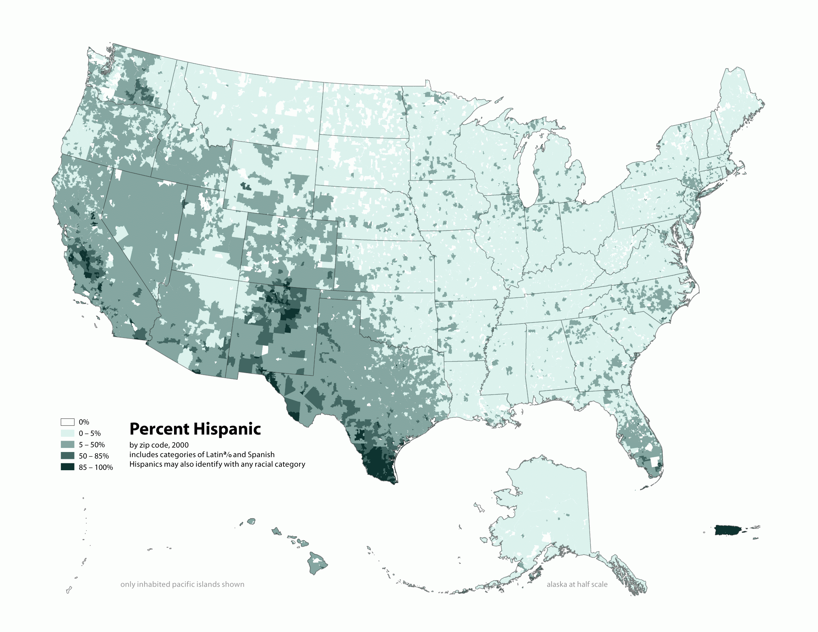
English: Map of contiguous US, showing percentage of population self-reporting as "Hispanic," by census tract, 2000. Data source: US Census. |
| Petsa | 3 Abril 2006 (original upload date) |
| Pinanggalingan | Sariling gawa |
| May-akda |
similar maps:
- Image:New 2000 asian density.gif
- Image:New 2000 asian percent.gif
- Image:New 2000 black density.gif
- Image:New 2000 black percent.gif
- Image:New 2000 hawaiian density.gif
- Image:New 2000 hawaiian percent.gif
- Image:New 2000 hispanic density.gif
- Image:New 2000 hispanic percent.gif
- Image:New 2000 indian density.gif
- Image:New 2000 indian percent.gif
- Image:New 2000 white density.gif
- Image:New 2000 white percent.gif
Paglilisensiya
Ang talaksang ito ay nakalisensiya sa ilalim ng lisensiyang Creative Commons Atribusyon-Pagpapamahaging Magkatulad 2.5 Heneriko.
- Malaya kang:
- para ibahagi – para kopyahin, ipamahagi, at i-transmit ang akda
- para i-remix – para i-adapt ang akda
- Sa ilalim ng mga kondisyong ito:
- atribusyon – Dapat magbigay ka ng isang maayos na pag-credit, ibigay ang link sa lisensiya, at tukuyin kung may mga pagbabagong ginawa. Magagawa mo ito sa isang risonableng paraan, pero hindi sa paraan na para bang ineendorso ka o ng paggamit mo ng naglisensiya sa'yo.
- share alike – Kung ire-remix mo, babaguhin, o magdadagdag ka sa materyal, dapat mong ipamahagi ang mga ambag mo sa ilalim ng pareho o katulad na lisensiya.
Tala ng orihinal na pagkarga
Transferred from en.wikipedia to Commons using For the Common Good.
The original description page was here. All following user names refer to en.wikipedia.
| Petsa/Oras | Sukat | Tagagamit | Komento |
|---|---|---|---|
| 19:17, 1 May 2010 | 2,604 × 2,012 (701,113 bytes) | w:en:Citynoise (usapan | ambag) | (Added Alaska, Hawaii, and Territories. Also changed from tracts to zip codes.) |
| 02:08, 3 April 2006 | 1,012 × 691 (72,987 bytes) | w:en:Citynoise (usapan | ambag) | (Map of contiguous US, showing percentage of population self-reporting as "Hispanic," in persons per square mile, by census tract, 2000. Data source: US Census. I am the designer and creator of this map and license it under the Creative Commons Attribu) |
Nakaraan ng file
Pindutin ang araw/oras upang makita kung papaano ang itsura ng talaksan noong oras na iyon.
| Araw/Oras | Thumbnail | Mga dimensiyon | tagagamit | Kumento | |
|---|---|---|---|---|---|
| ngayon | 15:11, 10 Pebrero 2013 | | 2,604 × 2,012 (685 KB) | Fredlyfish4 | Transferred from en.wikipedia: see original upload log above |
Mga ugnay
Nakaturo sa talaksan na ito ang mga sumusunod na mga pahina:
Pandaigdigang paggamit sa file
Ginagamit ng mga sumusunod na wiki ang file na ito:
- Paggamit sa en.wikipedia.org
- Paggamit sa es.wikipedia.org
- Paggamit sa fa.wikipedia.org
- Paggamit sa ru.wikipedia.org
- Paggamit sa uz.wikipedia.org