Talaksan:OrangeCountyCA Map.gif
Laki ng pasilip na ito: 685 x 599 na pixel. Ibang mga resolusyon: 274 x 240 na pixel | 549 x 480 na pixel | 878 x 768 na pixel | 1,170 x 1,024 na pixel | 2,341 x 2,048 na pixel | 3,200 x 2,800 na pixel.
Buong resolusyon ((3,200 × 2,800 pixel, laki ng talaksan: 1.35 MB, uri ng MIME: image/gif))
|
|
Ito ay isang talaksan mula sa Wikimedia Commons. Makikita sa ibaba ang impormasyon mula sa pahina ng paglalarawan nito roon. |

|
This locator map image could be re-created using vector graphics as an SVG file. This has several advantages; see Commons:Media for cleanup for more information. If an SVG form of this image is available, please upload it and afterwards replace this template with
{{vector version available|new image name}}.
It is recommended to name the SVG file “OrangeCountyCA Map.svg”—then the template Vector version available (or Vva) does not need the new image name parameter. |
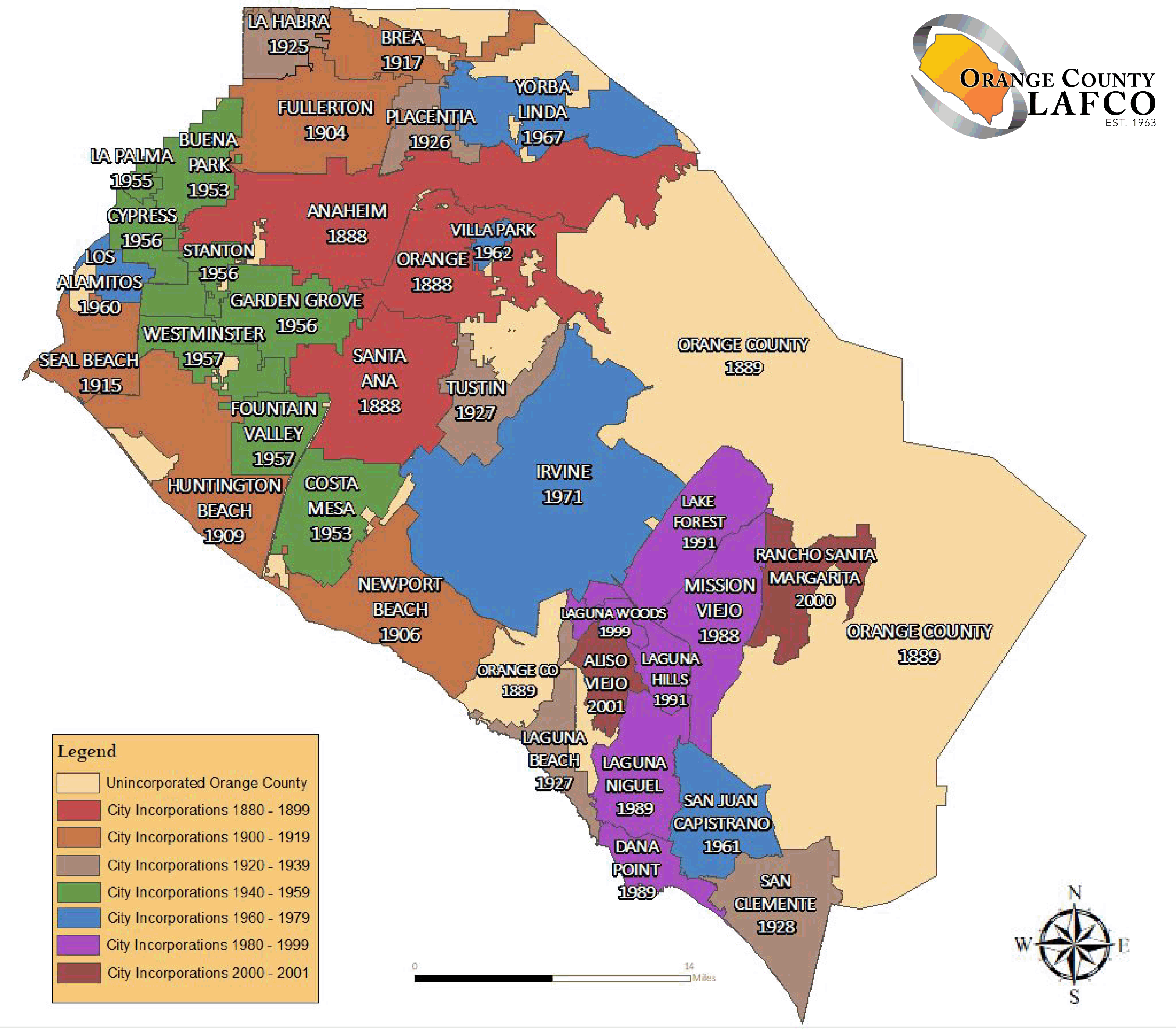
English: The en:Orange County LAFCO map of Category:Maps of Orange County with its city's boundaries.
Español: Mapa de las fronteras de las ciudades de Condado de Orange.
Français : Carte des frontières des villes du Comté d'Orange.
Source : import from English Wikipedia. http://en.wikipedia.org/wiki/Image:OrangeCountyCA_Map.gif - Author : MarsRover - public domain
| Ang akdang ito ay pinakawalan sa sakop ng madla ng may-akda nito, si MarsRover at English Wikipedia. Magagamit ito sa buong daigdig. Maaaring hindi ito posibleng legal sa ilang mga bansa; kung ganito: Ibinibigay ni MarsRover kaninuman ang karapatang gamitin ang akdang ito para sa anumang layunin, na walang anumang kundisyon, maliban na lamang kung ang ganyang mga kundisyon ay kinakailangan sa batas. |
Nakaraan ng file
Pindutin ang araw/oras upang makita kung papaano ang itsura ng talaksan noong oras na iyon.
| Araw/Oras | Thumbnail | Mga dimensiyon | tagagamit | Kumento | |
|---|---|---|---|---|---|
| ngayon | 03:36, 12 Setyembre 2019 | | 3,200 × 2,800 (1.35 MB) | Fluffy89502 | newer map per https://oclafco.org/index.php/sphere-of-influence-maps/ |
| 01:55, 30 Hulyo 2008 |  | 694 × 557 (29 KB) | MarsRover | {{Information |Description= |Source= |Date= |Author= |Permission= |other_versions= }} | |
| 15:35, 1 Oktubre 2006 |  | 694 × 557 (29 KB) | Laurent Nguyen | Orange County city boundary map. Carte des frontières des villes du Comté d'Orange. Source : import from English Wikipedia. http://en.wikipedia.org/wiki/Image:OrangeCountyCA_Map.gif - Author : MarsRover - public domain |
Mga ugnay
Nakaturo sa talaksan na ito ang mga sumusunod na mga pahina:
Pandaigdigang paggamit sa file
Ginagamit ng mga sumusunod na wiki ang file na ito:
- Paggamit sa af.wikipedia.org
- Paggamit sa cs.wikipedia.org
- Paggamit sa de.wikipedia.org
- Paggamit sa en.wikipedia.org
- Paggamit sa eo.wikipedia.org
- Paggamit sa es.wikipedia.org
- Paggamit sa fa.wikipedia.org
- Paggamit sa fr.wikipedia.org
- Paggamit sa it.wikipedia.org
- Paggamit sa ja.wikipedia.org
- Paggamit sa ml.wikipedia.org
- Paggamit sa ms.wikipedia.org
- Paggamit sa new.wikipedia.org
- Paggamit sa pt.wikipedia.org
- Paggamit sa ro.wikipedia.org
- Paggamit sa ru.wikipedia.org
- Paggamit sa sco.wikipedia.org
- Paggamit sa sv.wikipedia.org
- Paggamit sa ur.wikipedia.org
- Paggamit sa vi.wikipedia.org
- Paggamit sa zh.wikipedia.org