Talaksan:Panampangan Island.jpg

Buong resolusyon ((3,973 × 2,980 pixel, laki ng talaksan: 1.33 MB, uri ng MIME: image/jpeg))
|
|
Ito ay isang talaksan mula sa Wikimedia Commons. Makikita sa ibaba ang impormasyon mula sa pahina ng paglalarawan nito roon. |
Buod
| Paglalarawan |
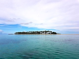
English: Panampangan island is located at the Basibuli Reef and possesses longest sandbar in the Philippines at the province of Tawi-Tawi. This was taken using the joint mapping, reconnaissance, and deployment mission of the Philippine Marine Corps and Schadow1 Expeditions |
||
| Petsa | |||
| Pinanggalingan | Sariling gawa | ||
| May-akda | Ervin Malicdem | ||
| Permiso (Muling paggamit sa file) |
Ang talaksang ito ay nakalisensiya sa ilalim ng lisensiyang Creative Commons Atribusyon-Pagpapamahaging Magkatulad 4.0 Pandaigdig.
|

| Camera location | | View this and other nearby images on: OpenStreetMap |
|---|
Initially published at Schadow1 Expeditions article available at http://www.s1expeditions.com/2017/06/217-panampangan-islandtawi-tawi.html
Nakaraan ng file
Pindutin ang araw/oras upang makita kung papaano ang itsura ng talaksan noong oras na iyon.
| Araw/Oras | Thumbnail | Mga dimensiyon | tagagamit | Kumento | |
|---|---|---|---|---|---|
| ngayon | 07:11, 15 Setyembre 2017 | | 3,973 × 2,980 (1.33 MB) | Schadow1 | User created page with UploadWizard |
Mga ugnay
Nakaturo sa talaksan na ito ang mga sumusunod na mga pahina:
Pandaigdigang paggamit sa file
Ginagamit ng mga sumusunod na wiki ang file na ito:
- Paggamit sa be.wikipedia.org
- Paggamit sa bjn.wikipedia.org
- Paggamit sa bn.wikipedia.org
- Paggamit sa ceb.wikipedia.org
- Paggamit sa en.wikipedia.org
- Paggamit sa fa.wikipedia.org
- Paggamit sa hr.wikipedia.org
- Paggamit sa id.wikipedia.org
- Paggamit sa ilo.wikipedia.org
- Paggamit sa mk.wikipedia.org
- Paggamit sa ms.wikipedia.org
- Paggamit sa simple.wikipedia.org
- Paggamit sa th.wikipedia.org
- Paggamit sa vi.wikipedia.org
- Paggamit sa www.wikidata.org
- Paggamit sa zh.wikipedia.org