Talaksan:Puertoprincesa chart4343 1904.jpeg
Laki ng pasilip na ito: 715 x 600 na pixel. Ibang mga resolusyon: 286 x 240 na pixel | 572 x 480 na pixel | 916 x 768 na pixel | 1,221 x 1,024 na pixel | 2,442 x 2,048 na pixel | 3,053 x 2,561 na pixel.
Buong resolusyon ((3,053 × 2,561 pixel, laki ng talaksan: 1.31 MB, uri ng MIME: image/jpeg))
|
|
Ito ay isang talaksan mula sa Wikimedia Commons. Makikita sa ibaba ang impormasyon mula sa pahina ng paglalarawan nito roon. |
| Paglalarawan |
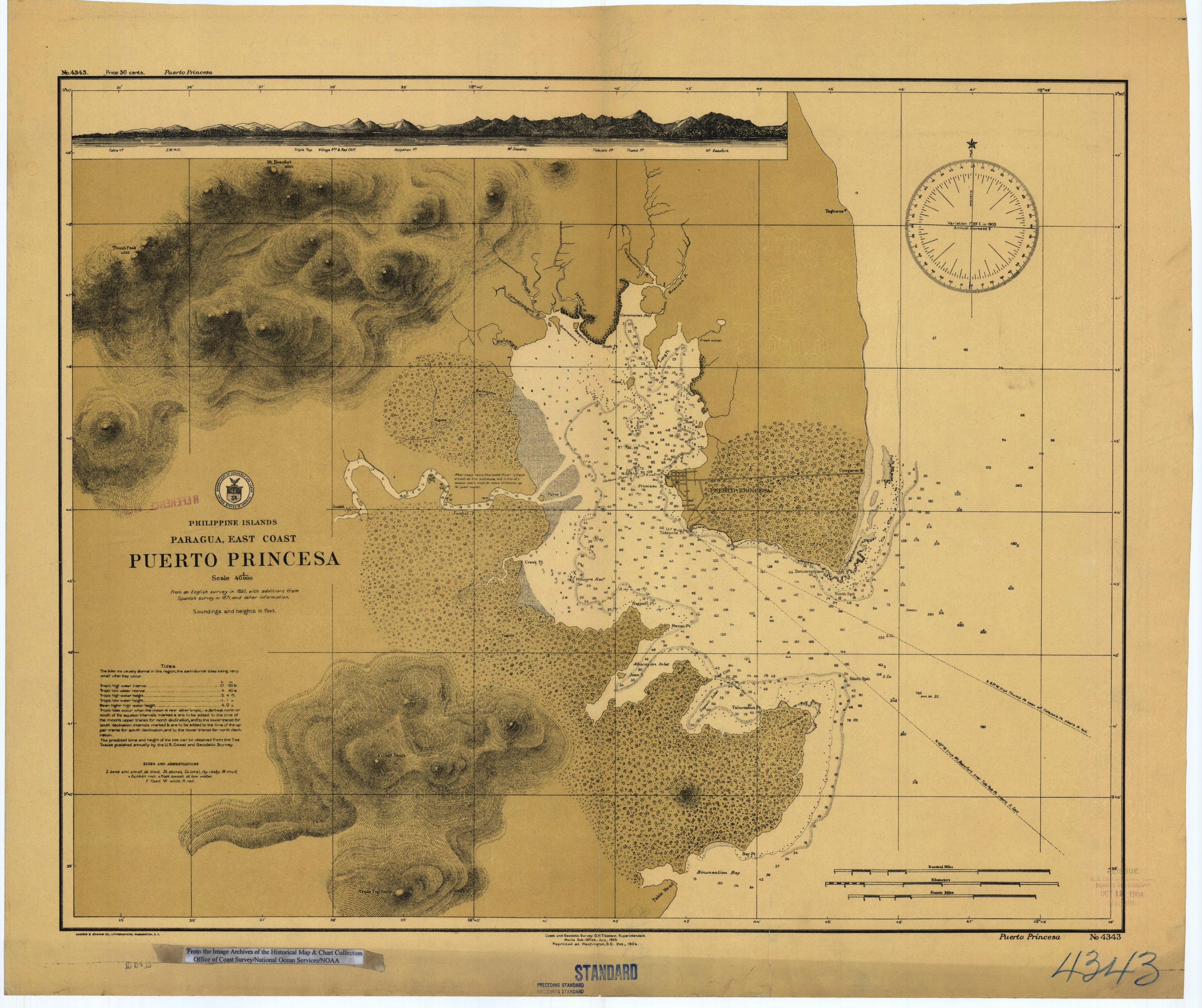
English: Scanned image of US Coast & Geodetic Survey (Manila Office) nautical chart #4343 Puerto Princesa, (Paragua), Palawan, Philippines. |
|||
| Petsa | ||||
| Pinanggalingan |
English: From the image archives of the Historical Map & Chart Collection/Office of Coast Survey/National Ocean Service/NOAA/United States government. Converted from MrSID to JPEG format for upload to Commons. |
|||
| May-akda | Coast and Geodetic Survey O.H. Tittmann, Superintendent. Manila Sub-Office. July 1903 | |||
| Permiso (Muling paggamit sa file) |
|
Nakaraan ng file
Pindutin ang araw/oras upang makita kung papaano ang itsura ng talaksan noong oras na iyon.
| Araw/Oras | Thumbnail | Mga dimensiyon | tagagamit | Kumento | |
|---|---|---|---|---|---|
| ngayon | 01:41, 17 Marso 2006 | | 3,053 × 2,561 (1.31 MB) | Cdc~commonswiki | Scanned image of US Coast & Geodetic Survey (Manila Office) nautical chart #4343 Puerto Princesa, (Paragua), Palawan, Philippines, 1904. From the Image Archives of the [http://chartmaker.ncd.noaa.gov/csdl/ctp/abstract.htm Historical Map & Chart Collecti |
Mga ugnay
Nakaturo sa talaksan na ito ang mga sumusunod na mga pahina:
Pandaigdigang paggamit sa file
Ginagamit ng mga sumusunod na wiki ang file na ito:
- Paggamit sa en.wikipedia.org
- Paggamit sa es.wikipedia.org
- Paggamit sa ja.wikipedia.org
- Paggamit sa ka.wikipedia.org
- Paggamit sa ko.wikipedia.org
- Paggamit sa pam.wikipedia.org
- Paggamit sa pt.wikipedia.org