Talaksan:1947 Nanhai Zhudao.png
Buong resolusyon ((2,654 × 3,840 pixel, laki ng talaksan: 4.42 MB, uri ng MIME: image/png))
|
|
Ito ay isang talaksan mula sa Wikimedia Commons. Makikita sa ibaba ang impormasyon mula sa pahina ng paglalarawan nito roon. |
Buod
| Paglalarawan |
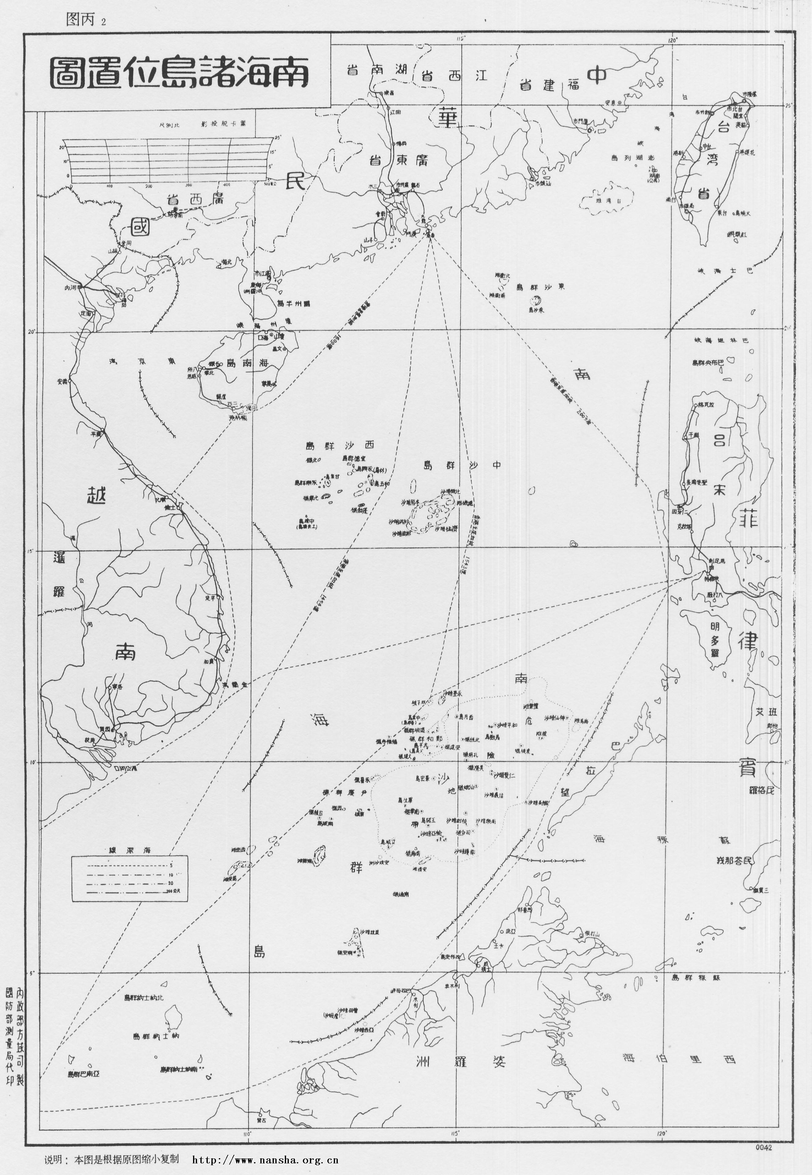
English: Location Map of South China Sea Islands, Secretariat of Government of Guangdong Province. January, 1947.
Left margin written as: Made by Territory Department of Ministry of the Interior, printed by Bereau of Surveying of Ministry of Defence. Now in Sun Yat-sen Library of Guangdong Province, China, this map describes Dongsha Islands, Xisha Islands and Zhongsha Islands in details. Every island has its name in Chinese and English, with depth of sea marks and descriptions as following: "November of 35th year of the Republic (A.D. 1946), Executive Yuan ordered the Navy Command Headquarter and Ministry of the Interior to assist Guangdong government to accept Nanhai Zhudao: ROCS Taiping, ROCS Zhongye to accept Tuansha Qundao, ROCS Yongxing, ROCS Zhongjian to accept Xisha Qundao. The mission is completed in December of the same year. In honor of the actions of Taiping Ship and Yongxing ship, Chang Island (長島) is renamed to Taiping Island (太平島), and the Lin Island (林島) is renamed to Yongxing Island (永興島) under orders. The Xiniao Island (西鳥島) is also called Spratly Island. Because it is located in the far south, so the Goverment renames it to Nanwei Island (南威島). The Ministry of the Interior adjusted the names of the islands according to their locations in the South China Sea, so changed Tuansha Islands (團沙群島) (i.e. Xinnan Islands (新南群島) by Japanese, Spratly Islands by Westerners) to Nansha Islands (南沙群島), and the former Japanese Nansha Islands (南沙群島) is renamed to Zhongsha Islands (中沙群島). The other islands and reefs are named after the historical diplomats to the Nanyang, in memory of them."中文:《南海諸島位置圖》1947年正月广东省政府秘书处编制。左侧写明:内政部方域司制,国防部测量局代印。现藏于广东省立中山图书馆。
图中详绘了东沙群岛、西沙群岛、中沙群岛,各岛屿有中英对照,海标均有深度,并附有说明: “中华民国三十五年十一月,行政院令海军总司令部、内政部协助广东省政府接收南海诸岛,并派太平舰、中业舰接收团沙群岛,永兴舰、中建舰接收西沙群岛, 同年十二月任务完成,为纪念太平舰、永兴舰之行之盛举,奉命将长岛改名为太平岛,林岛改名为永兴岛。本府以西鸟岛又名斯巴特列岛,远处南疆,特改为南威岛。 内政部为调整各群岛名称,复将团沙群岛(即日人所称之“新南群岛”,西人所称之Spratly群岛)改为南沙群岛,原曰之南沙群岛则改为中沙群岛, 以符诸岛在南海所处之位置。其余各岛洲礁多以历朝出任南洋使节之名以名之,以志纪念焉。” |
| Petsa | |
| Pinanggalingan |
Made by Territory Department of Ministry of the Interior, printed by Bereau of Surveying of Ministry of Defence. Now in Sun Yat-sen Library of Guangdong Province, China, this map describes Dongsha Islands, Xisha Islands and Zhongsha Islands in details. Every island has its name in Chinese and English, with depth of sea marks and descriptions as following: |
| May-akda | Secretariat of Government of Guangdong Province, Republic of China |
Ang larawang ito ay nasa pampublikong dominyo ngayon sa Tsina dahil napaso na ang buhay ng karapatang-ari nito. Ayon sa mga batas ng karapatang-ari sa Republikang Bayan ng Tsina (sa Kalupaan lamang ang ligal na saklaw at hindi kasama ang Hong Kong at Macao) at sa Republika ng Tsina (kasalukuyang may hurisdiksiyon sa Taiwan, Penghu, Kinmen, Matsu, atbp.), pumapasok sa pampublikong dominyo ang lahat ng mga retrato at gawang sinematograpo, at lahat ng mga gawang likha ng isang juristic person 50 taon pagkaraang unang nailathala ang mga ito, o kung hindi ay 50 taon kasunod ng paglikha ng mga ito, at pumapasok naman sa pampublikong dominyo ang lahat ng ibang mga kaugnay na gawa 50 taon kasunod ng pagpanaw ng maylikha. Mahalagang paalala: Ang mga gawang hindi buhat ng Estados Unidos ay dapat na wala na rin sa saklaw ng karapatang-ari o nasa malayang lisensiya kapuwa sa bansang pinagmulan ng mga ito at sa Estados Unidos upang matanggap ito sa Wikimedia Commons. Ang mga gawang buhat sa Tsina na nakapasok na sa Estados Unidos dahil sa ilang mga sitwasyon (tulad ng paglalathala nang hindi nakaalinsunod sa mga pormalidad ng Estados Unidos) ay maaaring naibalik ang kanilang karapatang-ari sa Estados Unidos sa ilalim ng Uruguay Round Agreements Act (URAA) kapag ang gawa ay nasa karapatang-ari sa bansang pinagmulan sa petsang nagkaroon ng bisa ang URAA sa gayong bansa. (Para sa Republikang Bayan ng Tsina, nagkaroon ng bisa ang URAA noong Enero 1, 1996. Para naman sa Republika ng Tsina (Taiwan), nagkaroon ng bisa ang URAA noong Enero 1, 2002.[1]) Para sa nagkarga ng retrato: Inihihiling na ibigay ang impormasyon kung kailang unang nailathala ang larawan at sino ang lumikha nito o unang humawak ng karapatang-ari nito.
|
  |
This work is in the public domain in the United States because it meets three requirements:
For background information, see the explanations on Non-U.S. copyrights.
Note: This tag should not be used for sound recordings. |
Nakaraan ng file
Pindutin ang araw/oras upang makita kung papaano ang itsura ng talaksan noong oras na iyon.
| Araw/Oras | Thumbnail | Mga dimensiyon | tagagamit | Kumento | |
|---|---|---|---|---|---|
| ngayon | 11:52, 6 Mayo 2008 | | 2,654 × 3,840 (4.42 MB) | Shibo77 | 说明:1947 《南中国海图》1947年正月广东省政府秘书处编制。 图中详绘了东沙群岛、西沙群岛、中沙群岛,各岛屿有中英对照,海标均有深度,并附有说明。 中华民国三十五年十一月,行政院� |
Mga ugnay
Nakaturo sa talaksan na ito ang mga sumusunod na mga pahina:
Pandaigdigang paggamit sa file
Ginagamit ng mga sumusunod na wiki ang file na ito:
- Paggamit sa en.wikipedia.org
- Spratly Islands
- South China Sea Islands
- Scarborough Shoal
- Spratly Islands dispute
- Nine-dash line
- South China Sea Arbitration
- Template:Did you know nominations/Philippines v. China
- Wikipedia:Featured picture candidates/March-2014
- Wikipedia:Featured picture candidates/1947 Nanhai Zhudao
- 2016 in the Philippines
- Timeline of the South China Sea dispute
- Paggamit sa en.wiktionary.org
- Paggamit sa fr.wikipedia.org
- Paggamit sa fr.wiktionary.org
- Paggamit sa id.wikipedia.org
- Paggamit sa incubator.wikimedia.org
- Paggamit sa it.wikipedia.org
- Paggamit sa ja.wikipedia.org
- Paggamit sa ko.wikipedia.org
- Paggamit sa no.wikipedia.org
- Paggamit sa pl.wikipedia.org
- Paggamit sa vi.wikipedia.org
- Paggamit sa vi.wiktionary.org
- Paggamit sa zh.wikipedia.org
- Paggamit sa zh.wikinews.org
- Paggamit sa zh.wikivoyage.org