Talaksan:2015 Pacific typhoon season summary.png

Laki ng pasilip na ito: 800 x 600 na pixel. Ibang mga resolusyon: 320 x 240 na pixel | 640 x 480 na pixel | 1,024 x 768 na pixel | 1,280 x 960 na pixel | 2,560 x 1,920 na pixel | 4,000 x 3,000 na pixel.
Buong resolusyon ((4,000 × 3,000 pixel, laki ng talaksan: 7.77 MB, uri ng MIME: image/png))
|
|
Ito ay isang talaksan mula sa Wikimedia Commons. Makikita sa ibaba ang impormasyon mula sa pahina ng paglalarawan nito roon. |

|
This file may be updated to reflect new information. If you wish to use a specific version of the file without new updates being mirrored, please upload the required version as a separate file. |
Buod
| Paglalarawan |
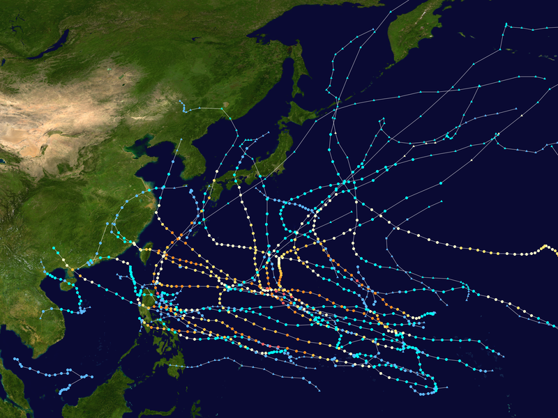
English: This map shows the tracks of all tropical cyclones in the 2015 Pacific typhoon season. The points show the location of each storm at 6-hour intervals. The colour represents the storm's maximum sustained wind speeds as classified in the Saffir-Simpson Hurricane Scale (see below), and the shape of the data points represent the type of the storm.
Tropical depression (≤38 mph, ≤62 km/h)
Tropical storm (39–73 mph, 63–118 km/h)
Category 1 (74–95 mph, 119–153 km/h)
Category 2 (96–110 mph, 154–177 km/h)
Category 3 (111–129 mph, 178–208 km/h)
Category 4 (130–156 mph, 209–251 km/h)
Category 5 (≥157 mph, ≥252 km/h)
Unknown
Storm type |
| Pinanggalingan | Created using Wikipedia:WikiProject Tropical cyclones/Tracks. The background image is from NASA [1]. The tracking data is from the Joint Typhoon Warning Center's best track database |
| May-akda | Keith Edkins |
| Ang akdang ito ay pinakawalan sa sakop ng madla ng may-akda nito, si Keith Edkins. Magagamit ito sa buong daigdig. Maaaring hindi ito posibleng legal sa ilang mga bansa; kung ganito: Ibinibigay ni Keith Edkins kaninuman ang karapatang gamitin ang akdang ito para sa anumang layunin, na walang anumang kundisyon, maliban na lamang kung ang ganyang mga kundisyon ay kinakailangan sa batas. |
Nakaraan ng file
Pindutin ang araw/oras upang makita kung papaano ang itsura ng talaksan noong oras na iyon.
| Araw/Oras | Thumbnail | Mga dimensiyon | tagagamit | Kumento | |
|---|---|---|---|---|---|
| ngayon | 02:48, 29 Pebrero 2020 | | 4,000 × 3,000 (7.77 MB) | Supportstorm | Primarily JTWC/JMA data |
| 05:28, 9 Disyembre 2018 |  | 4,000 × 3,530 (11.28 MB) | Supportstorm | Reverted to version as of 04:05, 11 October 2016 (UTC) | |
| 04:32, 28 Agosto 2018 |  | 4,000 × 3,000 (10.04 MB) | David Petrovsky | Added the dimensions and size both | |
| 04:05, 11 Oktubre 2016 |  | 4,000 × 3,530 (11.28 MB) | Supportstorm | Fixed 12W | |
| 04:01, 11 Oktubre 2016 |  | 4,000 × 3,530 (11.29 MB) | Supportstorm | Best tracks/ operational JMA TD data | |
| 16:43, 1 Enero 2016 |  | 4,000 × 3,460 (10.91 MB) | Supportstorm | Update | |
| 17:00, 26 Nobyembre 2015 |  | 4,000 × 3,460 (10.88 MB) | Supportstorm | Update | |
| 03:41, 17 Oktubre 2015 |  | 4,000 × 3,540 (12.74 MB) | Cyclonebiskit | Update (don't forget to change the line size "lines --0.04") | |
| 05:43, 8 Oktubre 2015 |  | 4,000 × 3,460 (10.78 MB) | Supportstorm | Update | |
| 16:47, 28 Setyembre 2015 |  | 4,000 × 3,540 (12.66 MB) | Cyclonebiskit | update, bump res to 4k |
Mga ugnay
Nakaturo sa talaksan na ito ang mga sumusunod na mga pahina:
Pandaigdigang paggamit sa file
Ginagamit ng mga sumusunod na wiki ang file na ito:
- Paggamit sa ar.wikipedia.org
- Paggamit sa de.wikipedia.org
- Paggamit sa en.wikipedia.org
- 2015 Pacific typhoon season
- User:Typhoon2013/2015 Pacific typhoon season
- Template:2015 Pacific typhoon season buttons
- Timeline of the 2015 Pacific typhoon season
- Tropical Storm Mekkhala (2015)
- Typhoon Maysak (2015)
- Typhoon Noul (2015)
- Typhoon Dolphin (2015)
- User:Nino Marakot/2015 Pacific typhoon season
- Tropical Storm Kujira (2015)
- Typhoon Chan-hom (2015)
- Tropical Storm Linfa (2015)
- Typhoon Nangka (2015)
- Typhoon Halola
- Typhoon Soudelor
- Tropical Storm Bavi (2015)
- Typhoon Goni (2015)
- Tropical Storm Etau (2015)
- Typhoon Dujuan (2015)
- Typhoon Mujigae
- Typhoon Koppu
- Tropical Storm Vamco (2015)
- Typhoon Melor
- User:Tfmbty/2015 Pacific typhoon season
- Tropical cyclones in 2015
- Hurricane Kilo
- Paggamit sa es.wikipedia.org
- Paggamit sa fr.wikipedia.org
- Paggamit sa ja.wikipedia.org
- Paggamit sa ko.wikipedia.org
- Paggamit sa nl.wikipedia.org
- Paggamit sa pt.wikipedia.org
Tingnan ang karagdagang pandaigdigang paggamit sa file na ito.