Talaksan:CH-NB Photoglob-Wehrli EAD-WEHR-32043-B.tiff

Buong resolusyon ((4,642 × 3,471 pixel, laki ng talaksan: 15.4 MB, uri ng MIME: image/tiff))
|
|
Ito ay isang talaksan mula sa Wikimedia Commons. Makikita sa ibaba ang impormasyon mula sa pahina ng paglalarawan nito roon. |
Buod
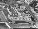
| Kairo, Landschaft
( |
|||||||||||||||||||||||||||
|---|---|---|---|---|---|---|---|---|---|---|---|---|---|---|---|---|---|---|---|---|---|---|---|---|---|---|---|
| Potograpo |
|
||||||||||||||||||||||||||
| Pamagat |
Kairo, Landschaft |
||||||||||||||||||||||||||
| Paglalarawan |
Aegypten, Kairo und Nil aus ca. 500 m Höhe, Ballonaufnahme |
||||||||||||||||||||||||||
| Depicted place | Kairo | ||||||||||||||||||||||||||
| Petsa | 1904 | ||||||||||||||||||||||||||
| Midyum | photograph | ||||||||||||||||||||||||||
| Sukat | height: 18 cm; width: 24 cm | ||||||||||||||||||||||||||
| Collection |
|
||||||||||||||||||||||||||
| Kasalukuyang lokasyon |
Prints and Drawings Department, Federal Archives of historic monuments |
||||||||||||||||||||||||||
| Bilang sa pagtatamo |
EAD-WEHR-32043-B |
||||||||||||||||||||||||||
| Mga tala | Published by Wehrli AG (1904-1924) [GND-ID 16137188-7] | ||||||||||||||||||||||||||
| Pinanggalingan | https://www.helveticarchives.ch/detail.aspx?id=162814 | ||||||||||||||||||||||||||
| Permiso (Muling paggamit sa file) |
|
||||||||||||||||||||||||||
| Iba pang mga bersyon | |||||||||||||||||||||||||||
.jpg)


| Camera location | | View this and other nearby images on: OpenStreetMap |
|---|
Paglilisensiya
|
The author died in 1931, so this work is in the public domain in its country of origin and other countries and areas where the copyright term is the author's life plus 80 years or fewer. This work is in the public domain in the United States because it was published (or registered with the U.S. Copyright Office) before January 1, 1929. | |
| Nakilala ang talaksan bilang malaya mula sa nalalamang mga paghahangga sa ilalim ng batas sa karapatang-ari, kasama ang lahat ng mga kaugnay at karatig na mga karapatan. | |
Nakaraan ng file
Pindutin ang araw/oras upang makita kung papaano ang itsura ng talaksan noong oras na iyon.
| Araw/Oras | Thumbnail | Mga dimensiyon | tagagamit | Kumento | |
|---|---|---|---|---|---|
| ngayon | 09:11, 22 Mayo 2014 |  | 4,642 × 3,471 (15.4 MB) | Swiss National Library | {{Information |Description ={{en|1=tmp}} |Source =tmp |Author =tmp |Date = |Permission = |other_versions = }} |
Mga ugnay
Nakaturo sa talaksan na ito ang mga sumusunod na mga pahina:
Pandaigdigang paggamit sa file
Ginagamit ng mga sumusunod na wiki ang file na ito:
- Paggamit sa ar.wikipedia.org
- Paggamit sa bn.wikipedia.org
- Paggamit sa de.wikipedia.org
- Paggamit sa en.wikipedia.org
- Paggamit sa eo.wikipedia.org
- Paggamit sa fr.wikipedia.org
- Paggamit sa hy.wikipedia.org
- Paggamit sa ig.wikipedia.org
- Paggamit sa it.wikipedia.org
- Paggamit sa la.wikipedia.org
- Paggamit sa pnb.wikipedia.org
- Paggamit sa si.wikipedia.org
- Paggamit sa sl.wikipedia.org
- Paggamit sa ur.wikipedia.org
- Paggamit sa vi.wikipedia.org
- Paggamit sa zh.wikipedia.org