Talaksan:Caucasus region 1994.jpg

Laki ng pasilip na ito: 782 x 600 na pixel. Ibang mga resolusyon: 313 x 240 na pixel | 626 x 480 na pixel | 1,002 x 768 na pixel | 1,280 x 982 na pixel | 2,560 x 1,963 na pixel | 3,119 x 2,392 na pixel.
Buong resolusyon ((3,119 × 2,392 pixel, laki ng talaksan: 1.18 MB, uri ng MIME: image/jpeg))
|
|
Ito ay isang talaksan mula sa Wikimedia Commons. Makikita sa ibaba ang impormasyon mula sa pahina ng paglalarawan nito roon. |
| Paglalarawan |
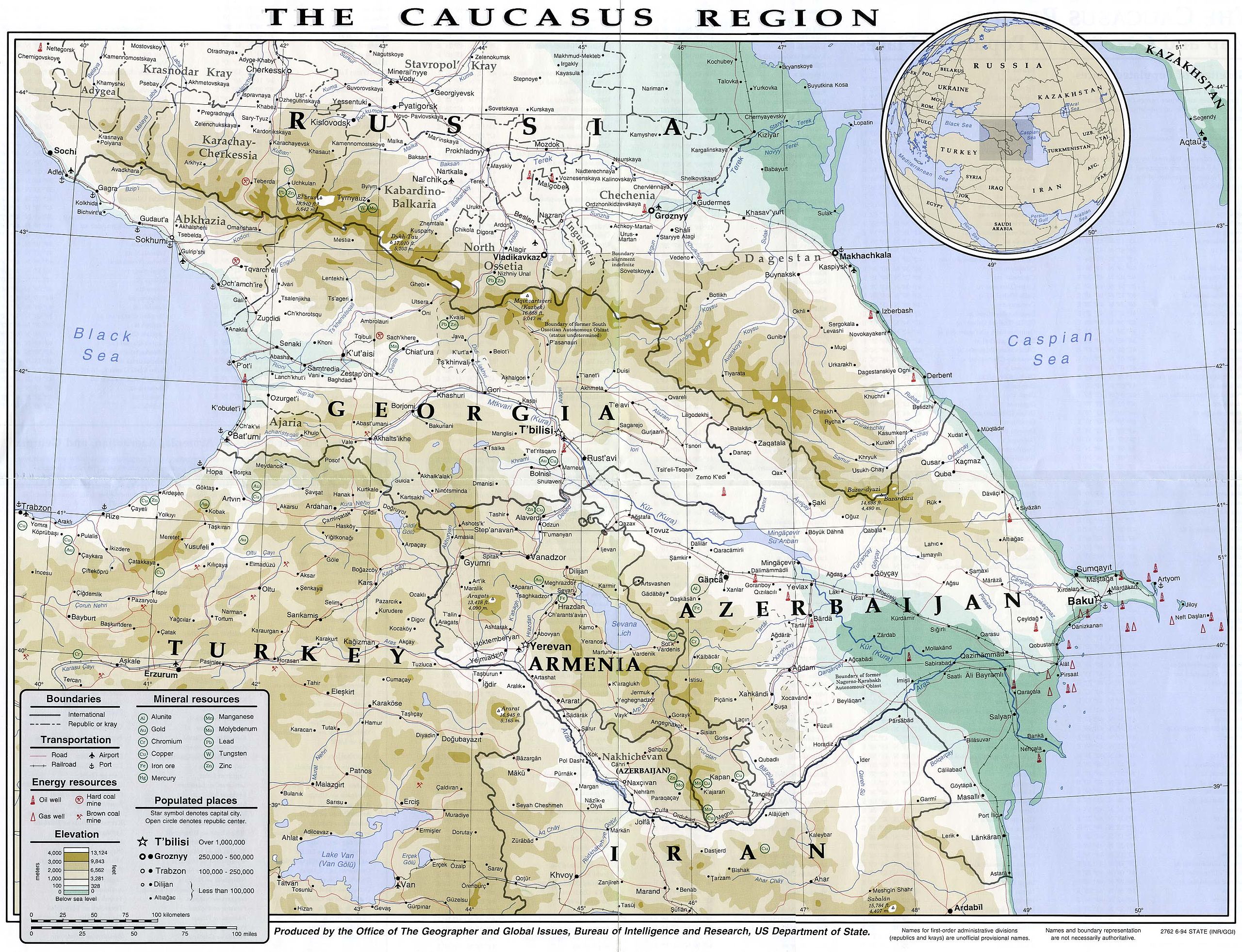
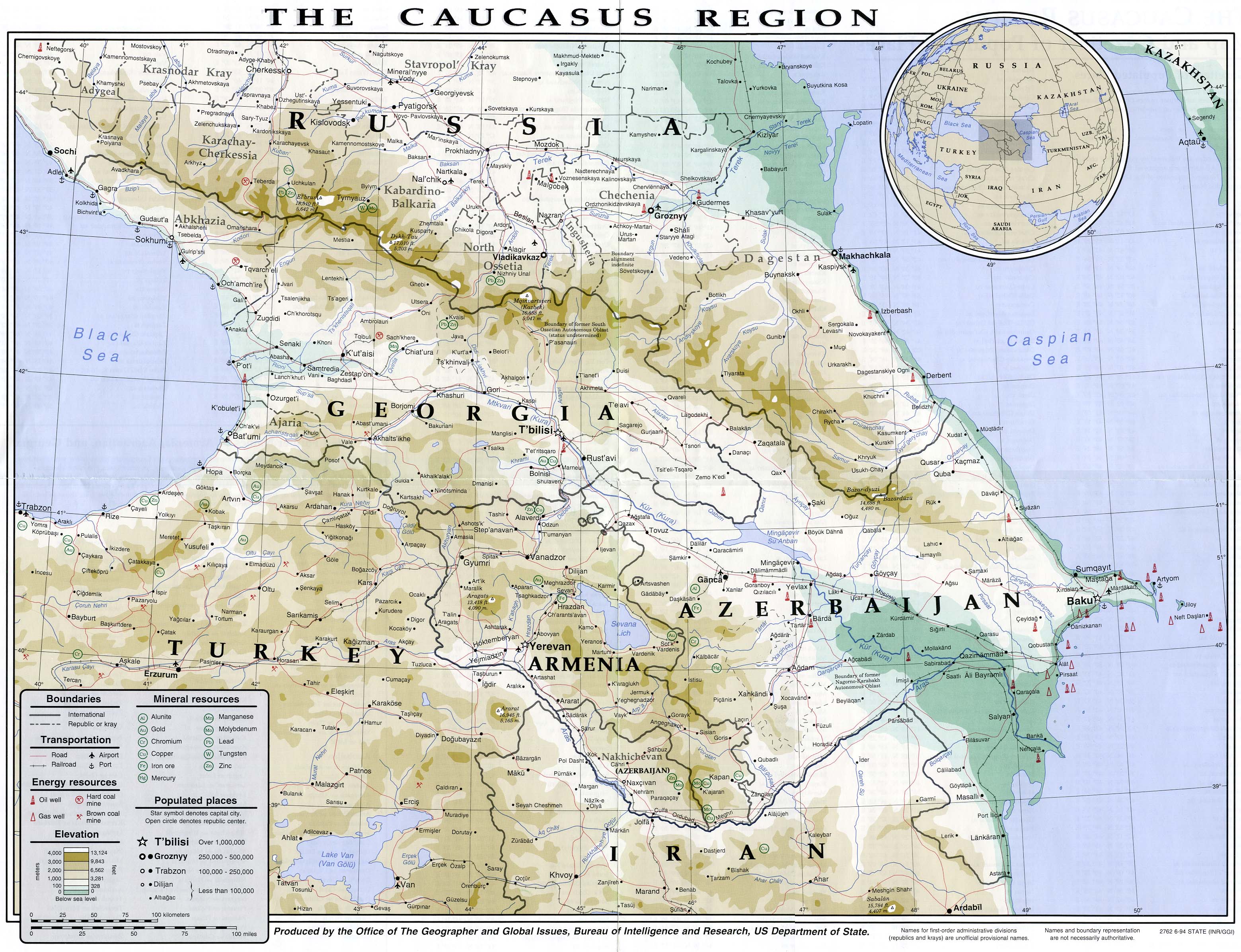
English: Map of the Caucasus region in 1994
Français : Carte du Caucase en 1994 |
|||
| Petsa | ||||
| Pinanggalingan | University of Texas Library | |||
| May-akda | CIA | |||
| Permiso (Muling paggamit sa file) |
|
|||
| Iba pang mga bersyon |


Nakaraan ng file
Pindutin ang araw/oras upang makita kung papaano ang itsura ng talaksan noong oras na iyon.
| Araw/Oras | Thumbnail | Mga dimensiyon | tagagamit | Kumento | |
|---|---|---|---|---|---|
| ngayon | 14:49, 16 Hulyo 2007 | | 3,119 × 2,392 (1.18 MB) | Pmx | {{Information |Description= {{en|Map of the Caucasus region in 1994}} {{fr|Carte du Caucase en 1994}} |Source=University of Texas Library [http://www.lib.utexas.edu/maps/commonwealth/caucasus_region_1994.jpg] |Date=1994 |Author=CIA |Permission=Public doma |
Mga ugnay
Nakaturo sa talaksan na ito ang mga sumusunod na mga pahina:
Pandaigdigang paggamit sa file
Ginagamit ng mga sumusunod na wiki ang file na ito:
- Paggamit sa ar.wikipedia.org
- Paggamit sa arz.wikipedia.org
- Paggamit sa ast.wikipedia.org
- Paggamit sa azb.wikipedia.org
- Paggamit sa az.wikipedia.org
- Paggamit sa ba.wikipedia.org
- Paggamit sa bg.wikipedia.org
- Paggamit sa bh.wikipedia.org
- Paggamit sa bs.wikipedia.org
- Paggamit sa ca.wikipedia.org
- Paggamit sa de.wikivoyage.org
- Paggamit sa en.wikipedia.org
- Paggamit sa eo.wikipedia.org
- Paggamit sa eu.wikipedia.org
- Paggamit sa fr.wikipedia.org
- Paggamit sa ga.wikipedia.org
- Paggamit sa he.wikipedia.org
- Paggamit sa hif.wikipedia.org
- Paggamit sa hr.wikipedia.org
- Paggamit sa hu.wikipedia.org
- Paggamit sa id.wikipedia.org
- Paggamit sa it.wikipedia.org
- Paggamit sa it.wikivoyage.org
- Paggamit sa kk.wikipedia.org
- Paggamit sa ko.wikipedia.org
- Paggamit sa ku.wikipedia.org
- Paggamit sa ml.wikipedia.org
- Paggamit sa ms.wikipedia.org
- Paggamit sa pnb.wikipedia.org
- Paggamit sa pt.wikipedia.org
- Paggamit sa ro.wikipedia.org
- Paggamit sa sl.wikipedia.org
- Paggamit sa so.wikipedia.org
- Paggamit sa su.wikipedia.org
- Paggamit sa sv.wikivoyage.org
- Paggamit sa ta.wikipedia.org
- Paggamit sa tg.wikipedia.org
- Paggamit sa th.wikipedia.org
Tingnan ang karagdagang pandaigdigang paggamit sa file na ito.