Talaksan:FukushimaMapCurrent.png

Laki ng pasilip na ito: 800 x 563 na pixel. Ibang mga resolusyon: 320 x 225 na pixel | 640 x 450 na pixel | 1,024 x 720 na pixel | 1,281 x 901 na pixel.
Buong resolusyon ((1,281 × 901 pixel, laki ng talaksan: 50 KB, uri ng MIME: image/png))
|
|
Ito ay isang talaksan mula sa Wikimedia Commons. Makikita sa ibaba ang impormasyon mula sa pahina ng paglalarawan nito roon. |
Buod
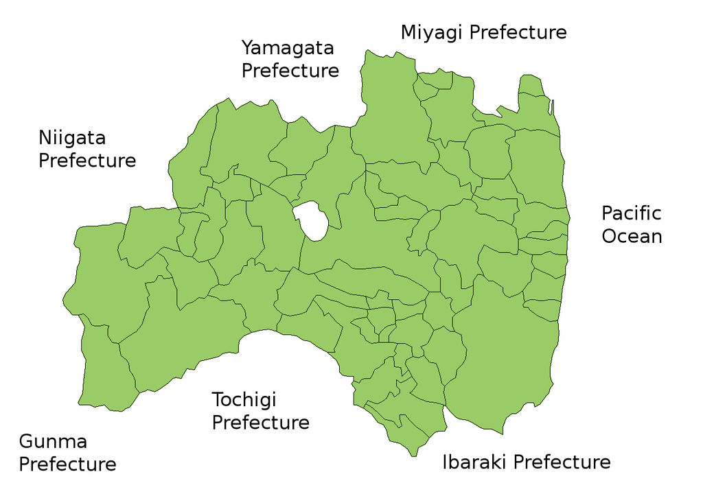
Map of Fukushima Prefecture, Japan.
Thanks to Aoki Shigenobu and [1]. Colors from Image:TokyoMapCurrent.png by User:Fg2.
Paglilisensiya

|
Shigenobu AOKI, the copyright holder of this work, allows anyone to use it for any purpose including unrestricted redistribution, commercial use, and modification.
|
Nakaraan ng file
Pindutin ang araw/oras upang makita kung papaano ang itsura ng talaksan noong oras na iyon.
| Araw/Oras | Thumbnail | Mga dimensiyon | tagagamit | Kumento | |
|---|---|---|---|---|---|
| ngayon | 15:58, 28 Setyembre 2011 | | 1,281 × 901 (50 KB) | Haaninjo | The city of Motomiya was created, and Iino merged into Fukushima. |
| 05:31, 19 Hulyo 2006 |  | 1,281 × 901 (50 KB) | Akanemoto~commonswiki | Reverted to earlier revision | |
| 12:23, 18 Hulyo 2006 |  | 1,050 × 800 (20 KB) | Akanemoto~commonswiki | remove texts | |
| 10:43, 18 Hulyo 2006 |  | 1,281 × 901 (50 KB) | Akanemoto~commonswiki | Map of Fukushima Prefecture, Japan. Thanks to Aoki Shigenobu and [http://aoki2.si.gunma-u.ac.jp/map/map.html]. Colors from Image:TokyoMapCurrent.png by User:Fg2. Category:Maps of Fukushima prefecture Category:Maps in English |
Mga ugnay
Walang mga pahina ang tumuturo sa talaksang ito.
Pandaigdigang paggamit sa file
Ginagamit ng mga sumusunod na wiki ang file na ito:
- Paggamit sa ast.wikipedia.org
- Paggamit sa az.wikipedia.org
- Paggamit sa ba.wikipedia.org
- Paggamit sa ckb.wikipedia.org
- Paggamit sa cs.wikipedia.org
- Paggamit sa es.wikipedia.org
- Paggamit sa eu.wikipedia.org
- Paggamit sa fa.wikipedia.org
- Paggamit sa gan.wikipedia.org
- Paggamit sa lt.wikipedia.org
- Paggamit sa ms.wikipedia.org
- Paggamit sa no.wikipedia.org
- Paggamit sa pam.wikipedia.org
- Paggamit sa pt.wikipedia.org
- Paggamit sa ru.wikipedia.org
- Paggamit sa su.wikipedia.org
- Paggamit sa vi.wikipedia.org