Talaksan:Italy 1000 AD.svg

Buong resolusyon ((Larawang SVG, tinatayang 565 × 811 mga pixel, laki ng talakasan: 861 KB))
|
|
Ito ay isang talaksan mula sa Wikimedia Commons. Makikita sa ibaba ang impormasyon mula sa pahina ng paglalarawan nito roon. |
Buod
| Paglalarawan |
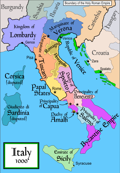
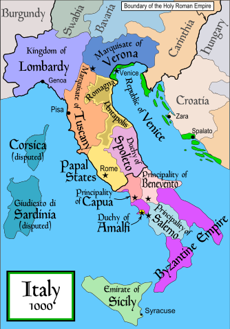
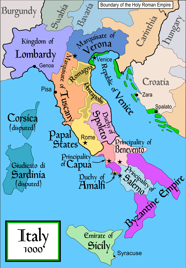
English: Political map of Italy in 1000 AD (CE). Created by MapMaster.
Part of a series of maps on the history of Italy:
|
| Petsa | 17 Nobyembre 2006 (original upload date) |
| Pinanggalingan | No machine-readable source provided. Own work assumed (based on copyright claims). |
| May-akda | No machine-readable author provided. MapMaster assumed (based on copyright claims). |
| Iba pang mga bersyon |
[]
SVG:
PNG:
|


|
This SVG file contains embedded text that can be translated into your language, using any capable SVG editor, text editor or the SVG Translate tool. For more information see: About translating SVG files. |
References
- Bjorklund, Oddvar; Holmboe, Haakon; Rohr, Anders (1970) Historical Atlas of the World, Barnes & Noble, NY, SBN: 389-00253-4.
- This map from Allyn & Bacon, Longman, textbook publishers.
- This map of the w:en:Holy Roman Empire
- A map from Attilios
- This map of 1050 AD Italy, from the 1923 The Historical Atlas by William R. Shepherd
- This map of 1000 AD Italy from Fordham University, adapted from Muir's Historical Atlas, (1911).
In addition, a number of other sources were consulted in an effort to determine the following matters:
- The extent of Venetian control over the cities of Dalmatia such as Zara and Spalato. Although the Venetians had been pushed off the mainland earlier, in the period around the year 1000, the Venetians made an effort to recover these cities.
- The extent of Saracen control over Corsica and Sardinia. Information is sparse. The apparent situation is that the Muslims had several bases on the coasts of these islands, but did not control the countryside (such as they did in Sicily).
- Whether or not the principalities of Capua and Benevento were separate states in the year 1000. Based on lists of their rulers (various Pandulfs and Landulfs), the answer seems to be "yes".
- Who controlled the Balkans on the southeastern border of the Kingdom of Croatia. Candidates include Bulgaria, the Byzantine Empire, Croatia, and Serbia.
As noted, there is significant disagreement among sources on these questions.
This map was commissioned by Attilios, and there is also a discussion to be found on MapMaster's English talk page.
Paglilisensiya

|
Pinapayagan ang pagkopya, pamamahagi, at/o pagbabago sa dokumentong ito sa ilalim ng mga nakasaad sa GNU Free Documentation License, Bersyon 1.2 o kahit anong mas bagong bersyong nilathala ng Free Software Foundation; nang walang pabago-bagong bahagi, walang teksto sa front-cover, at walang teksto sa back-cover. May nakalagay na kopya ng lisensiya sa bahaging pinamagatang GNU Free Documentation License. |
| Lisensyado ang file na ito sa ilalim ng lisensiyang Creative Commons Attribution-Share Alike 3.0 Unported. | ||
| ||
| Ang tatak ng paglilisensiya ay idinagdag sa talaksang ito bilang bahagi ng pagsasapanahon ng paglilinsensiya ng GFDL . |
derivative works
Derivative works of this file: Italya MS 1000.svg
Nakaraan ng file
Pindutin ang araw/oras upang makita kung papaano ang itsura ng talaksan noong oras na iyon.
| Araw/Oras | Thumbnail | Mga dimensiyon | tagagamit | Kumento | |
|---|---|---|---|---|---|
| ngayon | 19:50, 17 Abril 2007 | | 565 × 811 (861 KB) | MapMaster | Some further changes |
| 05:10, 19 Pebrero 2007 |  | 565 × 811 (824 KB) | MapMaster | changes to ensure consistency with my other Italy maps | |
| 05:39, 25 Nobyembre 2006 |  | 565 × 811 (823 KB) | MapMaster | Improved map. | |
| 14:44, 18 Nobyembre 2006 |  | 565 × 811 (827 KB) | MapMaster | Improved (I hope) version based on recommendations from Attilios. | |
| 21:50, 17 Nobyembre 2006 |  | 565 × 811 (768 KB) | MapMaster | Political map of Italy in 1000 AD (CE). |
Mga ugnay
Nakaturo sa talaksan na ito ang mga sumusunod na mga pahina:
Pandaigdigang paggamit sa file
Ginagamit ng mga sumusunod na wiki ang file na ito:
- Paggamit sa an.wikipedia.org
- Paggamit sa ar.wikipedia.org
- Paggamit sa ast.wikipedia.org
- Paggamit sa azb.wikipedia.org
- Paggamit sa az.wikipedia.org
- Paggamit sa bg.wikipedia.org
- Paggamit sa bn.wikipedia.org
- Paggamit sa bs.wikipedia.org
- Paggamit sa ckb.wikipedia.org
- Paggamit sa cs.wikipedia.org
- Paggamit sa da.wikipedia.org
- Paggamit sa de.wikipedia.org
- Paggamit sa el.wikipedia.org
- Paggamit sa en.wikipedia.org
- Lombards
- Pope Stephen IX
- Otto III, Holy Roman Emperor
- Otto II, Holy Roman Emperor
- Salerno
- Benevento
- Emirate
- Italian city-states
- List of historical states of Italy
- List of state leaders in the 10th century
- Duchy of Spoleto
- Duchy of Benevento
- Kalbids
- Guaimar IV of Salerno
- Rainulf Drengot
- Duchy of Amalfi
- Emirate of Sicily
- Sergius IV of Naples
Tingnan ang karagdagang pandaigdigang paggamit sa file na ito.