Talaksan:Jo-map.png
Walang resolusyong mataas.
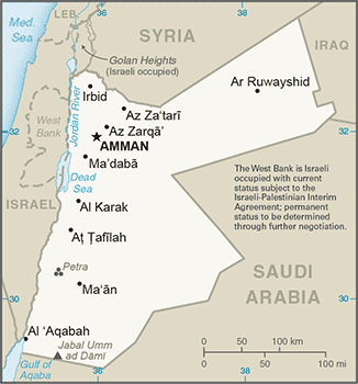
Jo-map.png ((326 × 350 pixel, laki ng talaksan: 60 KB, uri ng MIME: image/png))
|
|
Ito ay isang talaksan mula sa Wikimedia Commons. Makikita sa ibaba ang impormasyon mula sa pahina ng paglalarawan nito roon. |

|
This locator map image could be re-created using vector graphics as an SVG file. This has several advantages; see Commons:Media for cleanup for more information. If an SVG form of this image is available, please upload it and afterwards replace this template with
{{vector version available|new image name}}.
It is recommended to name the SVG file “Jo-map.svg”—then the template Vector version available (or Vva) does not need the new image name parameter. |
Buod
- Credits
- From CIA World Factbook.
This image is in the public domain because it contains materials that originally came from the United States Central Intelligence Agency's World Factbook.
|
 |
- in Esperanto: image:Jordanio.png
- in German: de:Bild:Jordanien.png
- in Arab: image:Jordan sm01.jpg
Nakaraan ng file
Pindutin ang araw/oras upang makita kung papaano ang itsura ng talaksan noong oras na iyon.
| Araw/Oras | Thumbnail | Mga dimensiyon | tagagamit | Kumento | |
|---|---|---|---|---|---|
| ngayon | 22:01, 29 Oktubre 2017 | | 326 × 350 (60 KB) | Neuenglander | Updated version |
| 07:27, 21 Hunyo 2007 |  | 328 × 352 (18 KB) | Hoshie | Updated map of Jordan from the CIA World Factbook, 14 June 07 rev. Src: https://www.cia.gov/library/publications/the-world-factbook/maps/jo-map.gif | |
| 14:15, 15 Abril 2005 |  | 329 × 354 (12 KB) | Oxhop | Map of Jordan from CIA World Factbook{{PD-USGov-CIA-WF}}Category:Jordan |
Mga ugnay
Nakaturo sa talaksan na ito ang mga sumusunod na mga pahina:
Pandaigdigang paggamit sa file
Ginagamit ng mga sumusunod na wiki ang file na ito:
- Paggamit sa af.wikipedia.org
- Paggamit sa ar.wikipedia.org
- Paggamit sa ast.wikipedia.org
- Paggamit sa azb.wikipedia.org
- Paggamit sa be-tarask.wikipedia.org
- Paggamit sa bg.wikipedia.org
- Paggamit sa bg.wiktionary.org
- Paggamit sa bjn.wikipedia.org
- Paggamit sa bn.wikipedia.org
- Paggamit sa br.wikipedia.org
- Paggamit sa ckb.wikipedia.org
- Paggamit sa cs.wikipedia.org
- Paggamit sa cv.wikipedia.org
- Paggamit sa da.wikipedia.org
- Paggamit sa de.wikipedia.org
- Paggamit sa dsb.wikipedia.org
- Paggamit sa el.wikipedia.org
- Paggamit sa en.wikipedia.org
- Paggamit sa es.wikipedia.org
- Paggamit sa eu.wikipedia.org
- Paggamit sa fa.wikipedia.org
- Paggamit sa fiu-vro.wikipedia.org
- Paggamit sa fi.wikipedia.org
- Paggamit sa fr.wikipedia.org
- Paggamit sa gd.wikipedia.org
- Paggamit sa gl.wikipedia.org
Tingnan ang karagdagang pandaigdigang paggamit sa file na ito.