Talaksan:Map of Russian districts, 2010-01-19.svg

Size of this PNG preview of this SVG file: 800 x 462 na pixel. Ibang mga resolusyon: 320 x 185 na pixel | 640 x 369 na pixel | 1,024 x 591 na pixel | 1,280 x 738 na pixel | 2,560 x 1,477 na pixel | 1,092 x 630 na pixel.
Buong resolusyon ((Larawang SVG, tinatayang 1,092 × 630 mga pixel, laki ng talakasan: 196 KB))
|
|
Ito ay isang talaksan mula sa Wikimedia Commons. Makikita sa ibaba ang impormasyon mula sa pahina ng paglalarawan nito roon. |
| Paglalarawan |
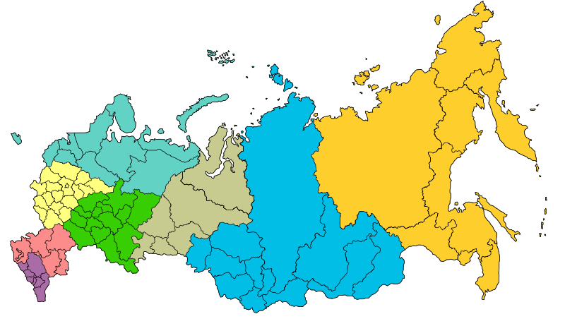
Map of the Federal districts of Russia with merged subjects (01.03.2008, last merger Chita Oblast+Agin-Buryat Autonomous Okrug to form Zabaykalsky Krai.) Central Federal District Southern Federal District Northwestern Federal District Far Eastern Federal District Siberian Federal District Urals Federal District Volga Federal District
North Caucasian Federal District |
| Petsa | (UTC) |
| Pinanggalingan | |
| May-akda |
|
| This is a retouched picture, which means that it has been digitally altered from its original version. The original can be viewed here: Map of Russian districts, 2008-03-01.svg:
|
Ako, na may karapatang-ari ng akdang ito, ang naglalathala nito alinsunod sa ilalim ng sumusunod na mga lisensya:
Ang talaksang ito ay nakalisensiya sa ilalim ng lisensiyang Creative Commons Atribusyon-Pagpapamahaging Magkatulad 2.5 Heneriko.
- Malaya kang:
- para ibahagi – para kopyahin, ipamahagi, at i-transmit ang akda
- para i-remix – para i-adapt ang akda
- Sa ilalim ng mga kondisyong ito:
- atribusyon – Dapat magbigay ka ng isang maayos na pag-credit, ibigay ang link sa lisensiya, at tukuyin kung may mga pagbabagong ginawa. Magagawa mo ito sa isang risonableng paraan, pero hindi sa paraan na para bang ineendorso ka o ng paggamit mo ng naglisensiya sa'yo.
- share alike – Kung ire-remix mo, babaguhin, o magdadagdag ka sa materyal, dapat mong ipamahagi ang mga ambag mo sa ilalim ng pareho o katulad na lisensiya.
Tala ng orihinal na pagkarga
This image is a derivative work of the following images:
- File:Map_of_Russian_districts,_2008-03-01.svg licensed with Cc-by-sa-2.5
- 2008-03-03T23:20:48Z Lokal Profil 1092x630 (260469 Bytes) Removed surrounding countries
- 2008-03-03T23:15:39Z Lokal Profil 1092x630 (296735 Bytes) {{Information |Description=Map of the [[:en:Federal districts of Russia|Federal districts of Russia]] with merged subjects (01.03.2008, last merger [[w:en:Chita Oblast|Chita Oblast]]+[[w:en:Agin-Buryat Autonomous Okrug|Agin-B
Uploaded with derivativeFX
Nakaraan ng file
Pindutin ang araw/oras upang makita kung papaano ang itsura ng talaksan noong oras na iyon.
| Araw/Oras | Thumbnail | Mga dimensiyon | tagagamit | Kumento | |
|---|---|---|---|---|---|
| ngayon | 14:44, 23 Marso 2014 | | 1,092 × 630 (196 KB) | Denniss | Reverted to version as of 23:59, 22 March 2014 |
| 13:29, 23 Marso 2014 |  | 1,092 × 630 (220 KB) | Preguntador | Reverted to version as of 11:28, 22 March 2014 | |
| 23:59, 22 Marso 2014 |  | 1,092 × 630 (196 KB) | Tibet2014 | The file is named 2010-01-19, please upload new version as new file | |
| 11:28, 22 Marso 2014 |  | 1,092 × 630 (220 KB) | Anton-rigin | Reverted to version as of 22:00, 21 March 2014/We can dispute about legality of referendum, but Russian federal districts are Russian domestic policy. | |
| 01:59, 22 Marso 2014 |  | 1,092 × 630 (196 KB) | Bobek | Reverted to version as of 16:25, 19 January 2010 | |
| 22:00, 21 Marso 2014 |  | 1,092 × 630 (220 KB) | Knyaz-1988 | New version | |
| 16:25, 19 Enero 2010 |  | 1,092 × 630 (196 KB) | SeNeKa~commonswiki | {{Information |Description=Map of the Federal districts of Russia with merged subjects (01.03.2008, last merger Chita Oblast+Agin-Buryat Autonomous Okrug to fo |
Mga ugnay
Nakaturo sa talaksan na ito ang mga sumusunod na mga pahina:
Pandaigdigang paggamit sa file
Ginagamit ng mga sumusunod na wiki ang file na ito:
- Paggamit sa av.wikipedia.org
- Paggamit sa bg.wikipedia.org
- Paggamit sa bxr.wikipedia.org
- Paggamit sa cy.wikipedia.org
- Paggamit sa de.wikipedia.org
- Paggamit sa de.wikivoyage.org
- Paggamit sa en.wikipedia.org
- Paggamit sa eo.wikipedia.org
- Paggamit sa fa.wikipedia.org
- Paggamit sa fi.wikipedia.org
- Paggamit sa fr.wikipedia.org
- Paggamit sa hr.wikipedia.org
- Paggamit sa hu.wikipedia.org
- Paggamit sa id.wikipedia.org
- Paggamit sa koi.wikipedia.org
- Шаблон:Федерал кытшшез Рочмуын
- Волгадор федерал кытш
- Категория:Ойвыв-Рытвыв федерал кытш
- Категория:Сибир федерал кытш
- Категория:Волгадор федерал кытш
- Категория:Урал федерал кытш
- Категория:Лунвыв федерал кытш
- Категория:Медшӧр федерал кытш
- Ылісь Асыввыв федерал кытш
- Категория:Ылісь Асыввыв федерал кытш
- Категория:Федерал кытшшез Рочмуын
- Категория:Ылiсь Асыввыв федерал кытш
- Категория:Медшöр федерал кытш
- Paggamit sa mk.wikipedia.org
Tingnan ang karagdagang pandaigdigang paggamit sa file na ito.