Talaksan:Okehocking HD Chesco PA.JPG

Laki ng pasilip na ito: 800 x 600 na pixel. Ibang resolusyon: 320 x 240 na pixel | 640 x 480 na pixel | 1,024 x 768 na pixel | 1,280 x 960 na pixel | 2,204 x 1,653 na pixel.
Buong resolusyon ((2,204 × 1,653 pixel, laki ng talaksan: 2.2 MB, uri ng MIME: image/jpeg))
|
|
Ito ay isang talaksan mula sa Wikimedia Commons. Makikita sa ibaba ang impormasyon mula sa pahina ng paglalarawan nito roon. |
|
This is an image of a place or building that is listed on the National Register of Historic Places in the United States of America. Its reference number is 93000719. |
Buod
| Paglalarawan |
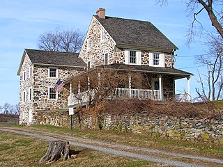
English: House in Okehocking Historic District on the NRHP since August 2, 1993. The HD is roughly bounded by West Chester Pike (S), Plumsock Road (E), Goshen Road (N), and Garrett Mill Road (W), about 6 miles east of West Chester, PA and a few miles NW of Ridley Creek Park, in Chester County, PA near the border with Delaware County. In 1703 500 acres was deeded by William Penn to the Okehocking band of Lennape (Delaware) Indians. They left before 1740 and land was settled by Quakers at that time. Very agricultural area with conservation easements and a township park, Quaker meeting house, Gentlemen Farmers' houses. This house is just off West Chester Pike (PA 3) near center from east to west. Willistown Township |
| Petsa | |
| Pinanggalingan | Sariling gawa |
| May-akda | Smallbones |
| Camera location | | View this and other nearby images on: OpenStreetMap |
|---|
Paglilisensiya
| Ako, ang may tangan ng karapatang-ari ng akdang ito, ay pinakakawalan ang akdang ito sa nasasakupan ng madla. Magagamit ito sa buong mundo. Maaaring hindi ito posibleng legal sa ilang mga bansa; kung ganito: Ibinibigay ko sa sinuman ang karapatang gamitin ang akdang ito para sa anumang layunin, na walang mga kundisyon, maliban na lang kung ang ganyang mga kundisyon ay kailangan ng batas. |
Nakaraan ng file
Pindutin ang araw/oras upang makita kung papaano ang itsura ng talaksan noong oras na iyon.
| Araw/Oras | Thumbnail | Mga dimensiyon | tagagamit | Kumento | |
|---|---|---|---|---|---|
| ngayon | 01:46, 24 Disyembre 2010 | | 2,204 × 1,653 (2.2 MB) | Smallbones | {{Information |Description={{en|1=House in Okehocking Historic District on the NRHP since August 2, 1993. The HD is roughly bounded by West Chester Pike (S), Plumsock Road (E), Goshen Road (N), and Garrett Mill Road (W), about 6 miles east of West Chester |
Mga ugnay
Nakaturo sa talaksan na ito ang mga sumusunod na mga pahina:
Pandaigdigang paggamit sa file
Ginagamit ng mga sumusunod na wiki ang file na ito:
- Paggamit sa en.wikipedia.org
- Paggamit sa fr.wikipedia.org
- Paggamit sa uk.wikipedia.org
- Paggamit sa www.wikidata.org