Talaksan:Pacific Ring of Fire.png
Laki ng pasilip na ito: 800 x 593 na pixel. Ibang mga resolusyon: 320 x 237 na pixel | 640 x 475 na pixel | 1,024 x 760 na pixel | 1,046 x 776 na pixel.
Buong resolusyon ((1,046 × 776 pixel, laki ng talaksan: 66 KB, uri ng MIME: image/png))
|
|
Ito ay isang talaksan mula sa Wikimedia Commons. Makikita sa ibaba ang impormasyon mula sa pahina ng paglalarawan nito roon. |

|
File:Pacific Ring of Fire.svg is a vector version of this file. It should be used in place of this PNG file.
File:Pacific Ring of Fire.png → File:Pacific Ring of Fire.svg
For more information, see Help:SVG. |
 |
Buod
| Paglalarawan |
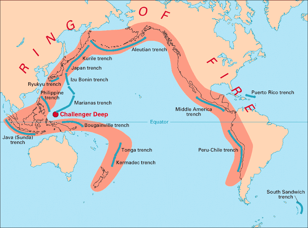
English: Volcanic arcs and oceanic trenches partly encircling the Pacific Basin form the so-called Pacific Ring of fire, a zone of frequent earthquakes and volcanic eruptions. The trenches are shown in blue-green. The volcanic island arcs, although not labelled, are parallel to, and always landward of, the trenches. For example, the island arc associated with the Aleutian Trench is represented by the long chain of volcanoes that make up the Aleutian Islands. |
| Petsa | |
| Pinanggalingan | http://pubs.usgs.gov/publications/text/fire.html |
| May-akda | USGS |
Paglilisensiya
This image is in the public domain in the United States because it only contains materials that originally came from the United States Geological Survey, an agency of the United States Department of the Interior. For more information, see the official USGS copyright policy.
|
Nakaraan ng file
Pindutin ang araw/oras upang makita kung papaano ang itsura ng talaksan noong oras na iyon.
| Araw/Oras | Thumbnail | Mga dimensiyon | tagagamit | Kumento | |
|---|---|---|---|---|---|
| ngayon | 03:28, 28 Disyembre 2004 | | 1,046 × 776 (66 KB) | Ævar Arnfjörð Bjarmason | Deeper colours |
| 03:26, 28 Disyembre 2004 |  | 1,046 × 776 (156 KB) | Ævar Arnfjörð Bjarmason |
Mga ugnay
Walang mga pahina ang tumuturo sa talaksang ito.
Pandaigdigang paggamit sa file
Ginagamit ng mga sumusunod na wiki ang file na ito:
- Paggamit sa als.wikipedia.org
- Paggamit sa ar.wikipedia.org
- Paggamit sa ary.wikipedia.org
- Paggamit sa bs.wikipedia.org
- Paggamit sa ca.wikipedia.org
- Paggamit sa da.wikipedia.org
- Paggamit sa dsb.wikipedia.org
- Paggamit sa en.wikipedia.org
- Paggamit sa en.wikibooks.org
- Paggamit sa eo.wikipedia.org
- Paggamit sa eu.wikipedia.org
- Paggamit sa fr.wikipedia.org
- Paggamit sa gl.wikipedia.org
- Paggamit sa hr.wikipedia.org
- Paggamit sa hsb.wikipedia.org
- Paggamit sa id.wikipedia.org
- Paggamit sa it.wikipedia.org
- Paggamit sa ko.wikipedia.org
- Paggamit sa ko.wikinews.org
- Paggamit sa lt.wikipedia.org
- Paggamit sa lv.wikipedia.org
- Paggamit sa mg.wikipedia.org
- Paggamit sa ms.wikipedia.org
- Paggamit sa nia.wikipedia.org
- Paggamit sa nl.wikipedia.org
- Paggamit sa nn.wikipedia.org
- Paggamit sa no.wikipedia.org
- Paggamit sa pap.wikipedia.org
- Paggamit sa pnb.wikipedia.org
- Paggamit sa ro.wikipedia.org
- Paggamit sa simple.wikipedia.org
- Paggamit sa sk.wikipedia.org
- Paggamit sa sl.wikipedia.org
- Paggamit sa sr.wikipedia.org
- Paggamit sa su.wikipedia.org
- Paggamit sa sv.wikipedia.org
Tingnan ang karagdagang pandaigdigang paggamit sa file na ito.