Talaksan:Map of Pyongyang - 1946 - Yanggak Bridge.png

Laki ng pasilip na ito: 758 x 600 na pixel. Ibang mga resolusyon: 304 x 240 na pixel | 607 x 480 na pixel | 971 x 768 na pixel | 1,072 x 848 na pixel.
Buong resolusyon ((1,072 × 848 pixel, laki ng talaksan: 1.95 MB, uri ng MIME: image/png))
|
|
Ito ay isang talaksan mula sa Wikimedia Commons. Makikita sa ibaba ang impormasyon mula sa pahina ng paglalarawan nito roon. |
Buod
| Paglalarawan |
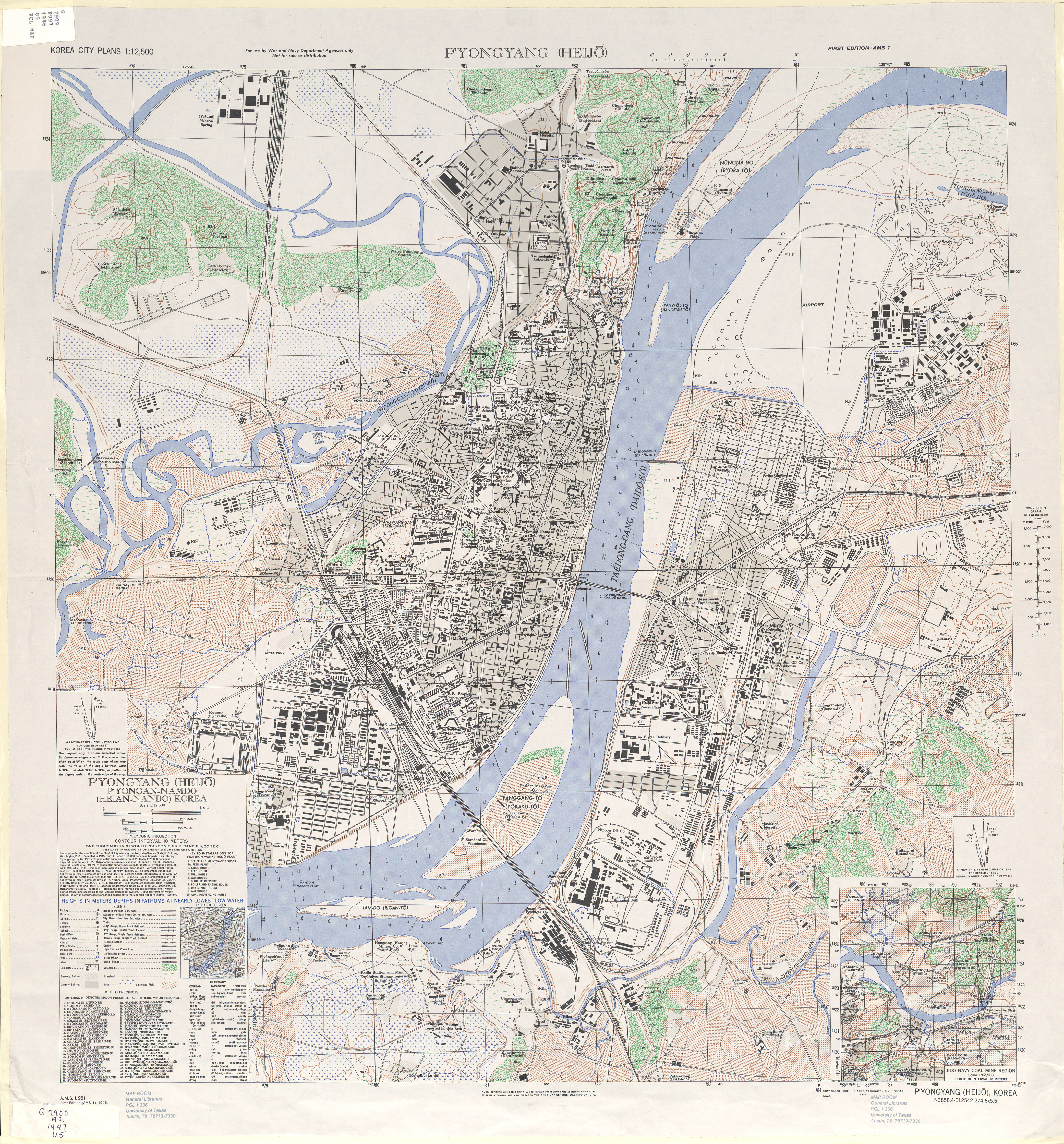
English: 1946 Map of Pyongyang (Heijo), North Korea by the Army Map Service, U.S. Army |
| Petsa | |
| Pinanggalingan | http://www.lib.utexas.edu/maps/ams/korea_city_plans/txu-oclc-6565231.jpg |
| May-akda |
Army Map Service, U.S. Army, Washington D.C. |
| Iba pang mga bersyon |

| This is a retouched picture, which means that it has been digitally altered from its original version. Modifications: Ausschnitt. The original can be viewed here: 1946 Map of Pyongyang, Army Map Service, US Army.jpg:
|
Paglilisensiya
This file is a work of a U.S. Army soldier or employee, taken or made as part of that person's official duties. As a work of the U.S. federal government, it is in the public domain in the United States.
|
 |
Tala ng orihinal na pagkarga
This image is a derivative work of the following images:
- File:1946 Map of Pyongyang, Army Map Service, US Army.jpg licensed with PD-USGov-Military-Army
- 2010-02-11T07:49:55Z AniRaptor2001 4168x4481 (8116435 Bytes) {{Information |Description={{en|1=1946 Map of Pyongyang (Heijo), North Korea by the Army Map Service, U.S. Army}} |Source=http://www.lib.utexas.edu/maps/ams/korea_city_plans/txu-oclc-6565231.jpg |Author=Army Map Service, U.S.
Nakaraan ng file
Pindutin ang araw/oras upang makita kung papaano ang itsura ng talaksan noong oras na iyon.
| Araw/Oras | Thumbnail | Mga dimensiyon | tagagamit | Kumento | |
|---|---|---|---|---|---|
| ngayon | 12:50, 25 Agosto 2011 | | 1,072 × 848 (1.95 MB) | Nicor | {{Information |Description={{en|1=1946 Map of Pyongyang (Heijo), North Korea by the Army Map Service, U.S. Army}} |Source=*File:Pyongyangarmymapservice1946.png |Date=2011-08-25 12:49 (UTC) |Author=*File:Pyongyangarmymapservice1946.png: Army Ma |
Mga ugnay
Nakaturo sa talaksan na ito ang mga sumusunod na mga pahina:
Pandaigdigang paggamit sa file
Ginagamit ng mga sumusunod na wiki ang file na ito:
- Paggamit sa cs.wikipedia.org
- Paggamit sa de.wikipedia.org
- Paggamit sa en.wikipedia.org
- Paggamit sa fa.wikipedia.org
- Paggamit sa ko.wikipedia.org
- Paggamit sa www.wikidata.org
- Paggamit sa zh.wikipedia.org