Talaksan:Sepat 2013 track.png

Laki ng pasilip na ito: 725 x 599 na pixel. Ibang mga resolusyon: 290 x 240 na pixel | 581 x 480 na pixel | 929 x 768 na pixel | 1,239 x 1,024 na pixel | 2,478 x 2,048 na pixel | 2,700 x 2,232 na pixel.
Buong resolusyon ((2,700 × 2,232 pixel, laki ng talaksan: 1.93 MB, uri ng MIME: image/png))
|
|
Ito ay isang talaksan mula sa Wikimedia Commons. Makikita sa ibaba ang impormasyon mula sa pahina ng paglalarawan nito roon. |
Buod
| Paglalarawan |
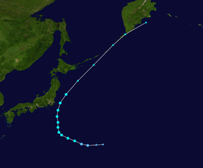
English: Track map of Tropical Storm Sepat of the 2013 Pacific typhoon season. The points show the location of the storm at 6-hour intervals. The colour represents the storm's maximum sustained wind speeds as classified in the (see below), and the shape of the data points represent the nature of the storm, according to the legend below. Tropical depression (≤38 mph, ≤62 km/h)
Tropical storm (39–73 mph, 63–118 km/h)
Category 1 (74–95 mph, 119–153 km/h)
Category 2 (96–110 mph, 154–177 km/h)
Category 3 (111–129 mph, 178–208 km/h)
Category 4 (130–156 mph, 209–251 km/h)
Category 5 (≥157 mph, ≥252 km/h)
Unknown
Storm type |
||
| Petsa | 2013-09-29–2013-10-03 | ||
| Pinanggalingan | Created by Meow using Wikipedia:WikiProject Tropical cyclones/Tracks. The background image is from NASA. Tracking data is from the Joint Typhoon Warning Center[1]. | ||
| May-akda | Meow | ||
| Source code | Track map data table, if present below, is in HURDAT2 or ATCF format. See format details in [2] and [3], respectively.
|
Paglilisensiya
| Ang akdang ito ay pinakawalan sa sakop ng madla ng may-akda nito, si Meow. Magagamit ito sa buong daigdig. Maaaring hindi ito posibleng legal sa ilang mga bansa; kung ganito: Ibinibigay ni Meow kaninuman ang karapatang gamitin ang akdang ito para sa anumang layunin, na walang anumang kundisyon, maliban na lamang kung ang ganyang mga kundisyon ay kinakailangan sa batas. |
Nakaraan ng file
Pindutin ang araw/oras upang makita kung papaano ang itsura ng talaksan noong oras na iyon.
| Araw/Oras | Thumbnail | Mga dimensiyon | tagagamit | Kumento | |
|---|---|---|---|---|---|
| ngayon | 06:37, 18 Setyembre 2014 | | 2,700 × 2,232 (1.93 MB) | Meow | Positions fixed |
| 03:24, 7 Setyembre 2014 |  | 2,700 × 2,232 (1.96 MB) | Supportstorm | IBTrACS version | |
| 07:19, 9 Hulyo 2014 |  | 2,700 × 2,232 (1.93 MB) | Meow | JTWC best track data extended with JMA best track data | |
| 17:17, 5 Oktubre 2013 |  | 2,000 × 1,640 (1.02 MB) | Supportstorm | Added extra-tropical points | |
| 07:30, 3 Oktubre 2013 |  | 2,000 × 1,236 (608 KB) | Keith Edkins | Update, believed to be final | |
| 08:48, 2 Oktubre 2013 |  | 2,000 × 1,236 (375 KB) | Keith Edkins | {{current}}{{Information |Description={{en|Track map of Tropical Storm Sepat of the 2013 Pacific typhoon season. The points show the location of the storm at 6-hou... |
Mga ugnay
Nakaturo sa talaksan na ito ang mga sumusunod na mga pahina:
Pandaigdigang paggamit sa file
Ginagamit ng mga sumusunod na wiki ang file na ito:
- Paggamit sa de.wikipedia.org
- Paggamit sa en.wikipedia.org
- Paggamit sa es.wikipedia.org
- Paggamit sa fr.wikipedia.org
- Paggamit sa ja.wikipedia.org
- Paggamit sa ko.wikipedia.org
- Paggamit sa pt.wikipedia.org
- Paggamit sa simple.wikipedia.org
- Paggamit sa th.wikipedia.org
- Paggamit sa vi.wikipedia.org
- Paggamit sa zh-yue.wikipedia.org
- Paggamit sa zh.wikipedia.org