Talaksan:Southeastern United States continental shelf.jpg

Walang resolusyong mataas.
Southeastern_United_States_continental_shelf.jpg ((462 × 374 pixel, laki ng talaksan: 41 KB, uri ng MIME: image/jpeg))
|
|
Ito ay isang talaksan mula sa Wikimedia Commons. Makikita sa ibaba ang impormasyon mula sa pahina ng paglalarawan nito roon. |
Buod
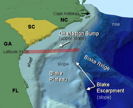
| Paglalarawan | Diagram of the continental shelf and slope of the southeastern United States leading down to the ocean floor. |
| Petsa | |
| Pinanggalingan | http://oceanexplorer.noaa.gov/explorations/04etta/background/profile/media/setting_2_462.jpg |
| May-akda | National Oceanic and Atmospheric Administration |
Paglilisensiya
This image is in the public domain because it contains materials that originally came from the U.S. National Oceanic and Atmospheric Administration, taken or made as part of an employee's official duties.
|
Nakaraan ng file
Pindutin ang araw/oras upang makita kung papaano ang itsura ng talaksan noong oras na iyon.
| Araw/Oras | Thumbnail | Mga dimensiyon | tagagamit | Kumento | |
|---|---|---|---|---|---|
| ngayon | 02:27, 1 Mayo 2010 | | 462 × 374 (41 KB) | Adrignola | {{Information |Description=Diagram of the continental shelf and slope of the southeastern United States leading down to the ocean floor. |Source=http://oceanexplorer.noaa.gov/explorations/04etta/background/profile/media/setting_2_462.jpg |Date=2010-04-30 |
Mga ugnay
Nakaturo sa talaksan na ito ang mga sumusunod na mga pahina:
Pandaigdigang paggamit sa file
Ginagamit ng mga sumusunod na wiki ang file na ito:
- Paggamit sa el.wikipedia.org
- Paggamit sa en.wikipedia.org
- Paggamit sa en.wikibooks.org
- Paggamit sa es.wikipedia.org
- Paggamit sa fa.wikipedia.org
- Paggamit sa fr.wikipedia.org
- Paggamit sa ka.wikipedia.org
- Paggamit sa sl.wikipedia.org
- Paggamit sa tr.wikipedia.org