Talaksan:Syrdaryamap.png
Laki ng pasilip na ito: 719 x 600 na pixel. Ibang resolusyon: 288 x 240 na pixel | 576 x 480 na pixel | 820 x 684 na pixel.
Buong resolusyon ((820 × 684 pixel, laki ng talaksan: 936 KB, uri ng MIME: image/png))
|
|
Ito ay isang talaksan mula sa Wikimedia Commons. Makikita sa ibaba ang impormasyon mula sa pahina ng paglalarawan nito roon. |
Buod

|
This map image could be re-created using vector graphics as an SVG file. This has several advantages; see Commons:Media for cleanup for more information. If an SVG form of this image is available, please upload it and afterwards replace this template with
{{vector version available|new image name}}.
It is recommended to name the SVG file “Syrdaryamap.svg”—then the template Vector version available (or Vva) does not need the new image name parameter. |
| Paglalarawan |
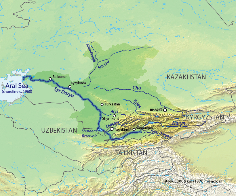
English: Map of the Syr Darya Basin watershed, of the Syr Darya and Chu Rivers — in Central Asia.
Қазақша: Сырдария
Татарча / tatarça: Сырдәрья |
| Petsa | to 06 |
| Pinanggalingan | Background and river course data from http://www2.demis.nl/mapserver/mapper.asp |
| May-akda | Background layer attributed to DEMIS Mapserver, map created by Shannon1 |
| Permiso (Muling paggamit sa file) |
Map created from DEMIS Mapserver, which are public domain. |
| Iba pang mga bersyon |
Derivative works of this file: |
Paglilisensiya
Ako, na may karapatang-ari ng akdang ito, ang naglalathala nito alinsunod sa ilalim ng sumusunod na mga lisensya:

|
Pinapayagan ang pagkopya, pamamahagi, at/o pagbabago sa dokumentong ito sa ilalim ng mga nakasaad sa GNU Free Documentation License, Bersyon 1.2 o kahit anong mas bagong bersyong nilathala ng Free Software Foundation; nang walang pabago-bagong bahagi, walang teksto sa front-cover, at walang teksto sa back-cover. May nakalagay na kopya ng lisensiya sa bahaging pinamagatang GNU Free Documentation License. |
This file is licensed under the Creative Commons Attribution-Share Alike 4.0 International, 3.0 Unported, 2.5 Generic, 2.0 Generic and 1.0 Generic license.
- Malaya kang:
- para ibahagi – para kopyahin, ipamahagi, at i-transmit ang akda
- para i-remix – para i-adapt ang akda
- Sa ilalim ng mga kondisyong ito:
- atribusyon – Dapat magbigay ka ng isang maayos na pag-credit, ibigay ang link sa lisensiya, at tukuyin kung may mga pagbabagong ginawa. Magagawa mo ito sa isang risonableng paraan, pero hindi sa paraan na para bang ineendorso ka o ng paggamit mo ng naglisensiya sa'yo.
- share alike – Kung ire-remix mo, babaguhin, o magdadagdag ka sa materyal, dapat mong ipamahagi ang mga ambag mo sa ilalim ng pareho o katulad na lisensiya.
Makakapili ka ng lisensiyang gusto mo.
Nakaraan ng file
Pindutin ang araw/oras upang makita kung papaano ang itsura ng talaksan noong oras na iyon.
| Araw/Oras | Thumbnail | Mga dimensiyon | tagagamit | Kumento | |
|---|---|---|---|---|---|
| ngayon | 03:11, 18 Oktubre 2013 | | 820 × 684 (936 KB) | Shannon1 | redrew and fixed watershed boundary |
| 09:21, 8 Enero 2011 |  | 1,101 × 866 (1.65 MB) | Sibom | chu | |
| 09:20, 8 Enero 2011 |  | 1,101 × 866 (1.65 MB) | Sibom | чу | |
| 03:04, 7 Pebrero 2010 |  | 1,101 × 866 (1.51 MB) | Shannon1 | {{Information |Description={{en|1=Map of the watershed of the Syr Darya in Central Asia, that drains to the Aral Sea.}} |Source=Background and river course data from http://www2.demis.nl/mapserver/mapper.asp |Author=Background layer attributed to DEMIS M |
Mga ugnay
Walang mga pahina ang tumuturo sa talaksang ito.
Pandaigdigang paggamit sa file
Ginagamit ng mga sumusunod na wiki ang file na ito:
- Paggamit sa af.wikipedia.org
- Paggamit sa ar.wikipedia.org
- Paggamit sa ast.wikipedia.org
- Paggamit sa bg.wikipedia.org
- Paggamit sa bh.wikipedia.org
- Paggamit sa bn.wikipedia.org
- Paggamit sa cs.wikipedia.org
- Paggamit sa cv.wikipedia.org
- Paggamit sa da.wikipedia.org
- Paggamit sa de.wikipedia.org
- Paggamit sa en.wikipedia.org
- Paggamit sa es.wikipedia.org
- Paggamit sa et.wikipedia.org
- Paggamit sa fi.wikipedia.org
- Paggamit sa fr.wikipedia.org
- Paggamit sa he.wikipedia.org
- Paggamit sa hi.wikipedia.org
- Paggamit sa hr.wikipedia.org
- Paggamit sa hu.wikipedia.org
- Paggamit sa hy.wikipedia.org
- Paggamit sa id.wikipedia.org
Tingnan ang karagdagang pandaigdigang paggamit sa file na ito.