Talaksan:World in 500 CE.png

Buong resolusyon ((4,000 × 2,036 pixel, laki ng talaksan: 1.72 MB, uri ng MIME: image/png))
|
|
Ito ay isang talaksan mula sa Wikimedia Commons. Makikita sa ibaba ang impormasyon mula sa pahina ng paglalarawan nito roon. |
| Paglalarawan |
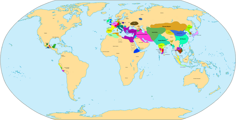
Main states inГК ЬФВЬФЬВФІВФІ
|
| Petsa | |
| Pinanggalingan | Sariling gawa |
| May-akda | Javierfv1212 |

|
This historical map image could be re-created using vector graphics as an SVG file. This has several advantages; see Commons:Media for cleanup for more information. If an SVG form of this image is available, please upload it and afterwards replace this template with
{{vector version available|new image name}}.
It is recommended to name the SVG file “World in 500 CE.svg”—then the template Vector version available (or Vva) does not need the new image name parameter. |
| Maps of world history | |
| BC | |
|
| |
| AD |
1 · 50 · 100 · 200 · 250 · 300 · 400 · 500 · 700 · 750 · 820 · 900 · 1200 · 1500 · 1556 · 1648 · 1700 · 1750 · 1815 · 1859 · 1871 · 1914 · 1935 · 1954 · 1989 · 2000 · |
|
Maps of colonization history | |
|
see also: Eastern Hemisphere only maps template (1300BC-1500AD) | |
| (this template: · view · discuss ) | |
.jpg)
._LOC_2001620596.jpg)
- Malaya kang:
- para ibahagi – para kopyahin, ipamahagi, at i-transmit ang akda
- para i-remix – para i-adapt ang akda
- Sa ilalim ng mga kondisyong ito:
- atribusyon – Dapat magbigay ka ng isang maayos na pag-credit, ibigay ang link sa lisensiya, at tukuyin kung may mga pagbabagong ginawa. Magagawa mo ito sa isang risonableng paraan, pero hindi sa paraan na para bang ineendorso ka o ng paggamit mo ng naglisensiya sa'yo.
- share alike – Kung ire-remix mo, babaguhin, o magdadagdag ka sa materyal, dapat mong ipamahagi ang mga ambag mo sa ilalim ng pareho o katulad na lisensiya.
Nakaraan ng file
Pindutin ang araw/oras upang makita kung papaano ang itsura ng talaksan noong oras na iyon.
| Araw/Oras | Thumbnail | Mga dimensiyon | tagagamit | Kumento | |
|---|---|---|---|---|---|
| ngayon | 17:19, 20 Marso 2009 | | 4,000 × 2,036 (1.72 MB) | Huhsunqu | Estados andinos |
| 21:25, 20 Mayo 2007 |  | 4,000 × 2,036 (1.72 MB) | Javierfv1212 | {{Information |Description=Main states in 500 CE |Source=self-made |Date=may 20 2007 |Author= User:Javierfv1212 }} Category:Maps of the world showing history |
Mga ugnay
Nakaturo sa talaksan na ito ang mga sumusunod na mga pahina:
Pandaigdigang paggamit sa file
Ginagamit ng mga sumusunod na wiki ang file na ito:
- Paggamit sa am.wikipedia.org
- Paggamit sa arz.wikipedia.org
- Paggamit sa ast.wikipedia.org
- Paggamit sa bs.wikipedia.org
- Paggamit sa ca.wikipedia.org
- Paggamit sa de.wikipedia.org
- Paggamit sa el.wikipedia.org
- Paggamit sa en.wikipedia.org
- Paggamit sa es.wikipedia.org
- Paggamit sa fr.wikipedia.org
- Paggamit sa gl.wikipedia.org
- Paggamit sa hu.wikipedia.org
- Paggamit sa id.wikipedia.org
- Paggamit sa ko.wikipedia.org
- Paggamit sa lt.wikipedia.org
- Paggamit sa mk.wikipedia.org
- Paggamit sa ms.wikipedia.org
- Paggamit sa my.wikipedia.org
- Paggamit sa nl.wikipedia.org
- Paggamit sa nn.wikipedia.org
- Paggamit sa no.wikipedia.org
- Paggamit sa ro.wikipedia.org
- Paggamit sa ru.wikipedia.org
- Paggamit sa shn.wikipedia.org
- Paggamit sa sh.wikipedia.org
- Paggamit sa sv.wikipedia.org
- Paggamit sa ta.wikipedia.org
- Paggamit sa uk.wikipedia.org
- Paggamit sa zh.wikipedia.org