Talaksan:Hammurabi's Babylonia 1.svg
Buong resolusyon((Larawang SVG, tinatayang 655 × 570 mga pixel, laki ng talakasan: 183 KB))

 
W3C-validity not checked.

Buod

Paglalarawan

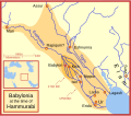
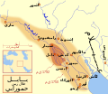
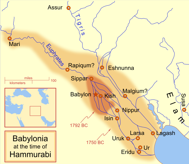
A locator map of Hammurabi's Babylonia, showing the Babylonian territory upon his ascension in 1792 BC and upon his death in 1750 BC. The river courses and coastline are those of that time period -- in general, they are not the modern rivers or coastlines. This is a Mercator projection, with north in its usual position

There is some question to what degree the cities of Nineveh, Tuttul, and Assur were under Babylonian authority. While in his introduction to his code of laws, Hammurabi claims lordship over these cities, Roaf does not include any of these in his map, upon which this map is based, and Chevalas states that "Assur and Nineveh were held for a very few years" (p. 155). Therefore, I have not included them as under Hammurabi's control in 1750 BC.
Petsa
Pinanggalingan Sariling gawa
May-akda MapMaster
Iba pang mga bersyon

[baguhin]

See also

References

  • Bjorklund, Oddvar; Holmboe, Haakon; Rohr, Anders (1970) Historical Atlas of the World, Barnes & Noble, NY, SBN: 389-00253-4.
  • Chavalas, Mark W.; K. Lawson Younger (2003) Mesopotamia and the Bible, Continuum International Publishing Group, ISBN 978-0567082312.
  • Hammond World Atlas Corporation (2007) Historical World Atlas, ISBN 9-780843-71391-6
  • Roaf, M. (1990) Cultural Atlas of Mesopotamia and the ancient Near East, Oxford: Facts on File. (In general, the basis for the ancient river courses and ancient coastline).
  • Van De Mieroop, Marc (2005). King Hammurabi of Babylon: A Biography. Blackwell Publishing. ISBN 1405126604

Paglilisensiya

Ako, na may karapatang-ari ng akdang ito, ang naglalathala nito alinsunod sa ilalim ng sumusunod na mga lisensya:
GNU head Pinapayagan ang pagkopya, pamamahagi, at/o pagbabago sa dokumentong ito sa ilalim ng mga nakasaad sa GNU Free Documentation License, Bersyon 1.2 o kahit anong mas bagong bersyong nilathala ng Free Software Foundation; nang walang pabago-bagong bahagi, walang teksto sa front-cover, at walang teksto sa back-cover. May nakalagay na kopya ng lisensiya sa bahaging pinamagatang GNU Free Documentation License.
w:tl:Creative Commons
atribusyon share alike
This file is licensed under the Creative Commons Attribution-Share Alike 4.0 International, 3.0 Unported, 2.5 Generic, 2.0 Generic and 1.0 Generic license.
Malaya kang:
  • para ibahagi – para kopyahin, ipamahagi, at i-transmit ang akda
  • para i-remix – para i-adapt ang akda
Sa ilalim ng mga kondisyong ito:
  • atribusyon – Dapat magbigay ka ng isang maayos na pag-credit, ibigay ang link sa lisensiya, at tukuyin kung may mga pagbabagong ginawa. Magagawa mo ito sa isang risonableng paraan, pero hindi sa paraan na para bang ineendorso ka o ng paggamit mo ng naglisensiya sa'yo.
  • share alike – Kung ire-remix mo, babaguhin, o magdadagdag ka sa materyal, dapat mong ipamahagi ang mga ambag mo sa ilalim ng pareho o katulad na lisensiya.
Makakapili ka ng lisensiyang gusto mo.

Captions

Add a one-line explanation of what this file represents
Babylonian

Items portrayed in this file

depicts English

copyrighted English

18 Pebrero 2008

MIME type English

image/svg+xml

Nakaraan ng file

Pindutin ang araw/oras upang makita kung papaano ang itsura ng talaksan noong oras na iyon.

(Pinakabago | Pinakauna) Tingnan (mas bagong 10) () (10 | 20 | 50 | 100 | 250 | 500).
Araw/OrasThumbnailMga dimensiyontagagamitKumento
ngayon09:14, 21 Abril 2013Thumbnail para sa bersyon noong 09:14, 21 Abril 2013655 × 570 (183 KB)CitypeekCleanup of file. Valid SVG now.
19:06, 27 Abril 2010Thumbnail para sa bersyon noong 19:06, 27 Abril 2010655 × 570 (168 KB)DieBucheremoved border
15:05, 30 Hulyo 2009Thumbnail para sa bersyon noong 15:05, 30 Hulyo 2009661 × 580 (317 KB)Amit6Some nodes changed.
23:24, 3 Marso 2008Thumbnail para sa bersyon noong 23:24, 3 Marso 2008661 × 580 (163 KB)MapMasterAdded city-state, moved Sippar, minor other changes based on recent Kassite map
16:06, 23 Pebrero 2008Thumbnail para sa bersyon noong 16:06, 23 Pebrero 2008661 × 580 (161 KB)MapMasterAdded 1 city, added name for 1 city
03:29, 21 Pebrero 2008Thumbnail para sa bersyon noong 03:29, 21 Pebrero 2008661 × 580 (159 KB)MapMaster"blurred" the territory outlines
23:25, 20 Pebrero 2008Thumbnail para sa bersyon noong 23:25, 20 Pebrero 2008661 × 580 (155 KB)MapMasterChanges made based on info from ''Mesopotamia and the Bible''
02:03, 19 Pebrero 2008Thumbnail para sa bersyon noong 02:03, 19 Pebrero 2008663 × 580 (156 KB)MapMasterFixed an error on my part
21:12, 18 Pebrero 2008Thumbnail para sa bersyon noong 21:12, 18 Pebrero 2008332 × 292 (156 KB)MapMastersome minor edits
19:19, 18 Pebrero 2008Thumbnail para sa bersyon noong 19:19, 18 Pebrero 2008332 × 293 (154 KB)MapMasterremoved unrenderable bmp
(Pinakabago | Pinakauna) Tingnan (mas bagong 10) () (10 | 20 | 50 | 100 | 250 | 500).

Nakaturo sa talaksan na ito ang mga sumusunod na mga pahina:

Pandaigdigang paggamit sa file

Ginagamit ng mga sumusunod na wiki ang file na ito:

Tingnan ang karagdagang pandaigdigang paggamit sa file na ito.

Metadata