Talaksan:Qing China 1820.png
Laki ng pasilip na ito: 800 x 593 na pixel. Ibang resolusyon: 320 x 237 na pixel | 640 x 475 na pixel | 910 x 675 na pixel.
Buong resolusyon ((910 × 675 pixel, laki ng talaksan: 327 KB, uri ng MIME: image/png))
|
|
Ito ay isang talaksan mula sa Wikimedia Commons. Makikita sa ibaba ang impormasyon mula sa pahina ng paglalarawan nito roon. |
| Paglalarawan |
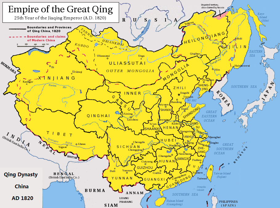
English: Map of the Qing Dynasty China in 1820. (Includes provincial boundaries and the boundaries of modern China for reference.) Adapted from http://en.wikipedia.org/wiki/Image:ROC_PRC_comparison_eng.jpg and information complied from other sources such as http://baike.baidu.com/view/5405.htm , http://map.huhai.net/58-59.jpg and http://www.sina7.com/jdwh/UploadFiles_6109/200709/20070918093610860.jpg 中文(简体):大清嘉庆二十五年疆域图。 中文(繁體):大清嘉慶廿五年疆域圖。 日本語: 大清の嘉慶25年の疆域の図。 Tiếng Việt: Đại Thanh bản đồ (1820). |
| Petsa | (UTC) |
| Pinanggalingan |
|
| May-akda |
|
| This is a retouched picture, which means that it has been digitally altered from its original version. Modifications: border islands. The original can be viewed here: Qing Dynasty 1820.png:
|
Ako, na may karapatang-ari ng akdang ito, ang naglalathala nito alinsunod sa ilalim ng sumusunod na mga lisensya:
Lisensyado ang file na ito sa ilalim ng lisensiyang Creative Commons Attribution-Share Alike 3.0 Unported.
- Malaya kang:
- para ibahagi – para kopyahin, ipamahagi, at i-transmit ang akda
- para i-remix – para i-adapt ang akda
- Sa ilalim ng mga kondisyong ito:
- atribusyon – Dapat magbigay ka ng isang maayos na pag-credit, ibigay ang link sa lisensiya, at tukuyin kung may mga pagbabagong ginawa. Magagawa mo ito sa isang risonableng paraan, pero hindi sa paraan na para bang ineendorso ka o ng paggamit mo ng naglisensiya sa'yo.
- share alike – Kung ire-remix mo, babaguhin, o magdadagdag ka sa materyal, dapat mong ipamahagi ang mga ambag mo sa ilalim ng pareho o katulad na lisensiya.

|
Pinapayagan ang pagkopya, pamamahagi, at/o pagbabago sa dokumentong ito sa ilalim ng mga nakasaad sa GNU Free Documentation License, Bersyon 1.2 o kahit anong mas bagong bersyong nilathala ng Free Software Foundation; nang walang pabago-bagong bahagi, walang teksto sa front-cover, at walang teksto sa back-cover. May nakalagay na kopya ng lisensiya sa bahaging pinamagatang GNU Free Documentation License. |
Makakapili ka ng lisensiyang gusto mo.
Tala ng orihinal na pagkarga
This image is a derivative work of the following images:
- File:Qing_Dynasty_1820.png licensed with Cc-by-sa-3.0, GFDL
- 2010-06-22T03:48:22Z Benlisquare 910x675 (363965 Bytes) Revert - redraw the map yourself. MS Paint overlaying of a corner is an eyesore. Illogical to have the title repeated twice.
- 2010-06-21T21:46:33Z Hisacw 910x675 (395648 Bytes) rv to NPOVify: the status on certain outlier islands (e.g. Sakhalin) is not explicitly defined, c.f. the map [http://go-passport.grolier.com/map?id=mh00032&pid=go]
- 2010-06-20T05:59:11Z Benlisquare 910x675 (363965 Bytes) Reverted to version as of 19:58, 27 September 2008
- 2010-06-20T05:58:44Z Benlisquare 910x675 (363965 Bytes) possible POV vandal
- 2010-06-19T05:34:53Z Hisacw 910x675 (395648 Bytes) small adj from original
- 2008-10-15T02:32:20Z Pryaltonian 910x675 (363965 Bytes) Reverted to version as of 19:58, 27 September 2008
- 2008-10-15T02:29:27Z Pryaltonian 910x675 (400039 Bytes) [[Category:China]] [[Category:Taiwan]] [[Category:Tibet]] [[Category:Mongolia]]
- 2008-09-27T19:58:02Z Pryaltonian 910x675 (363965 Bytes) {{Information |Description={{en|1=Map of the Qing Dynasty at its greatest extent. Includes provincial boundaries and the boundaries of modern China for reference.}} |Source=Own work by uploader |Author=[[User:Pryaltonian|Pry
Uploaded with derivativeFX
Nakaraan ng file
Pindutin ang araw/oras upang makita kung papaano ang itsura ng talaksan noong oras na iyon.
| Araw/Oras | Thumbnail | Mga dimensiyon | tagagamit | Kumento | |
|---|---|---|---|---|---|
| ngayon | 06:02, 23 Pebrero 2020 | | 910 × 675 (327 KB) | Morrisonjohn022 | Reverted to version as of 17:00, 23 July 2011 (UTC) While the indigenous peoples of Sakhalin was not Han Chinese, Sakhalin was claimed by the Qing Empire and it was recognized as such by other countries (until the 1858 Treaty of Aigun and 1860 Treaty of Peking gave the island to Russia). See p. 11 of "Restless Empire: China and the World Since 1750" by Odd Arne Westad, p. 200 of "Ethnic Groups of North, East, and Central Asia: An Encyclopedia" by James B. Minahan, and p. 2 of "Across Forest,... |
| 12:35, 26 Oktubre 2019 |  | 910 × 675 (386 KB) | Artanisen | Reverted to version as of 22:40, 24 October 2010 (UTC) Sakhalin was not Chinese. It was first occupied by the indigenous Ainu people and later it became half Japanese (Karafuto) and Russian (Sakhalin) then it became wholly part of the Russian Federation after WW2 | |
| 17:00, 23 Hulyo 2011 |  | 910 × 675 (327 KB) | Shibo77 | .. | |
| 22:40, 24 Oktubre 2010 |  | 910 × 675 (386 KB) | Wengier | minor | |
| 22:35, 24 Oktubre 2010 |  | 910 × 675 (386 KB) | Wengier | {{Information |Description={{en|1=Map of the Qing Dynasty China in 1820. (Includes provincial boundaries and the boundaries of modern China for reference.)<br/>Adapted from http://en.wikipedia.org/wiki/Image:ROC_PRC_comparison_eng.jpg and information comp |
Mga ugnay
Nakaturo sa talaksan na ito ang mga sumusunod na mga pahina:
Pandaigdigang paggamit sa file
Ginagamit ng mga sumusunod na wiki ang file na ito:
- Paggamit sa bcl.wikipedia.org
- Paggamit sa be.wikipedia.org
- Paggamit sa bn.wikipedia.org
- Paggamit sa en.wikipedia.org
- Paggamit sa hi.wikipedia.org
- Paggamit sa ml.wikipedia.org
- Paggamit sa pl.wikipedia.org
- Paggamit sa pnb.wikipedia.org
- Paggamit sa ru.wikipedia.org
- Paggamit sa ur.wikipedia.org
- Paggamit sa zh.wikipedia.org